Precision in Renovation: How Laser Scanning and BIM Modelling Streamline Building Upgrades

scan to BIM laser scanning

Renovating historic or complex buildings presents unique challenges. Accurate documentation of existing conditions is crucial to ensure successful upgrades and modernisation. Traditional surveying methods often fall short in capturing the intricate details required for precise planning. This is where advanced technologies like laser scanning and Building Information Modelling (BIM) come into play.

The Role of Laser Scanning in Building Renovation

Laser scanning, also known as LiDAR (Light Detection and Ranging), is a method of capturing high-resolution, three-dimensional data of physical spaces. By emitting laser beams and measuring their reflections, laser scanners create detailed point clouds that represent the exact dimensions and features of a building.(Pointscan)

This technology is particularly beneficial for renovation projects, where understanding the existing structure is paramount. Laser scanning provides accurate as-built data, reducing the risk of errors and unforeseen issues during the renovation process. It also facilitates better communication among stakeholders by providing a clear visual representation of the building’s current state.

Bute Building houses the Welsh School of Architecture and Cardiff School of Journalism

Integrating BIM for Enhanced Planning and Execution

Building Information Modelling (BIM) is a digital representation of a building’s physical and functional characteristics. When combined with laser scanning data, BIM allows for the creation of detailed 3D models that serve as a comprehensive reference throughout the renovation process.

These models enable architects, engineers, and contractors to visualise the project in its entirety, identify potential clashes, and plan accordingly. BIM also supports efficient facility management post-renovation, as it contains valuable information about building components and systems.

Case Study: Bute Building, Cardiff University

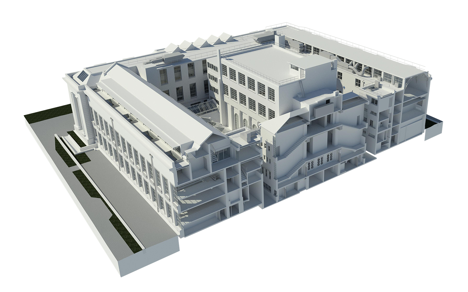
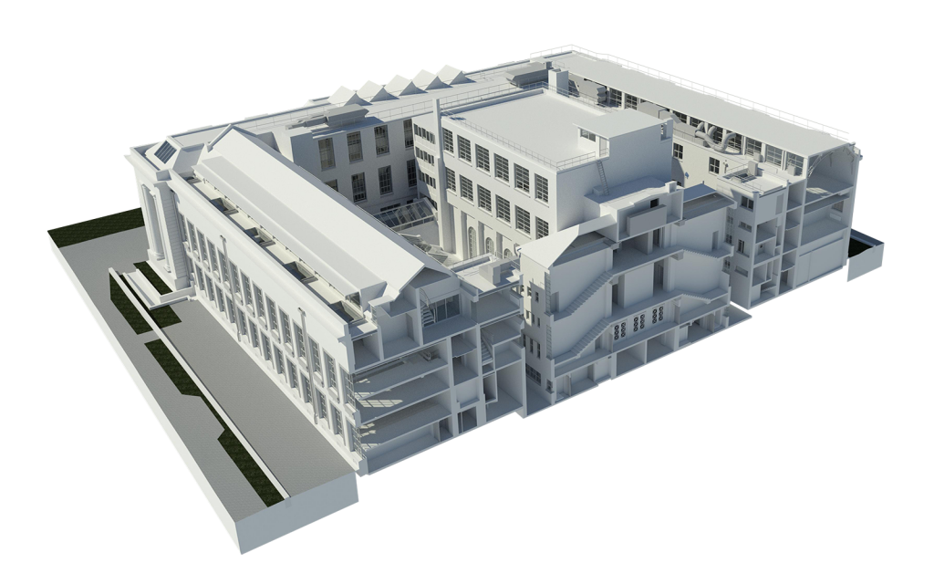
The Bute Building at Cardiff University, home to the Welsh School of Architecture and Cardiff School of Journalism, Media and Cultural Studies, is a prime example of how laser scanning and BIM can facilitate complex renovations. Constructed in 1916, the neoclassical building has undergone several additions, resulting in a network of small rooms and varied architectural features.

Cardiff University aimed to renovate the building to create more open spaces, improving flow and enhancing the student experience. To achieve this, Platinum 3D Consultants conducted a comprehensive laser scan of the building using Faro and Leica scanners, supplemented by drone surveys to capture inaccessible roof areas.

The collected data was processed into a registered point cloud, forming the basis for an LOD3 (Level of Detail 3) architectural Revit model. This model included essential MEP (Mechanical, Electrical, and Plumbing) elements like radiators and major plant components. The detailed model provided architects and the university with an accurate representation of the building, facilitating informed decision-making throughout the renovation process.

Benefits of Laser Scanning and BIM in Renovation Projects

Accuracy and Efficiency

Laser scanning captures precise measurements, reducing the likelihood of errors and rework. This accuracy streamlines the renovation process, saving time and resources.

Enhanced Collaboration

The detailed BIM models derived from laser scans serve as a central reference point for all stakeholders, promoting better communication and coordination.

Risk Mitigation

By providing a clear understanding of existing conditions, laser scanning and BIM help identify potential issues early, allowing for proactive solutions and reducing the risk of costly surprises during construction.

Lifecycle Management

The information-rich BIM models support ongoing facility management, enabling efficient maintenance and future upgrades.
scan to BIM laser scanning

Why Choose Platinum 3D Consultants?

Platinum 3D Consultants specialise in capturing and modelling existing buildings with unparalleled precision. Our team utilises the latest laser scanning technology and BIM software to deliver accurate, detailed models that serve as the foundation for successful renovation projects.

Our experience with complex structures, such as the Bute Building, demonstrates our capability to handle intricate renovations. We understand the importance of preserving historical integrity while integrating modern functionalities, ensuring that each project meets both aesthetic and operational goals.

Advantages

Incorporating laser scanning and BIM into renovation projects offers significant advantages, from improved accuracy and efficiency to enhanced collaboration and risk mitigation. These technologies provide a comprehensive understanding of existing structures, enabling informed decision-making and successful outcomes.

Platinum 3D Consultants are at the forefront of this technological integration, offering expert services that transform the way renovations are planned and executed. Whether dealing with historic buildings or complex modern structures, our team delivers the precision and insight necessary for exceptional results. 

Ready to Renovate With Confidence?

If you’re planning a renovation, upgrade or refurbishment project—especially one involving a heritage or complex building—don’t leave accuracy to chance. At Platinum 3D Consultants, we deliver laser-precise measured surveys, BIM-ready Revit models, and expert support every step of the way.

Get in touch today to find out how our survey and modelling services can help you save time, reduce risk, and unlock the full potential of your building.
How Measured Surveys and 3D Tech Are Changing the Way We Work With Buildings

natural history museum

In a world where precision, efficiency, and collaboration matter more than ever, the construction and property industries are undergoing a digital transformation. Whether you’re planning a refurbishment, managing a large estate, or preparing for a complex demolition, the old ways of working from paper plans and rough measurements are fast becoming outdated.

Measured building surveys, laser scanning, BIM, and digital walkthroughs are now working in tandem to deliver a clearer picture of the built environment—literally and figuratively. At the centre of this shift are experts like Platinum 3D Consultants, who combine decades of industry experience with cutting-edge technology to provide powerful tools that transform how buildings are understood and managed.

laser scanning BIM Revit

A New Era in Understanding Buildings

It all starts with measured surveys—precision recordings of a building’s size, structure, and spatial relationships. These aren’t just basic sketches or general layouts. Using high-specification laser scanning equipment, Platinum 3D captures millions of data points in minutes, creating incredibly accurate 3D representations of the existing environment.

This laser scan data is then processed into what’s known as a point cloud—a digital mesh of the building’s geometry. From there, this data can be used to generate everything from 2D plans to BIM-ready Revit models and fully immersive virtual tours.

For clients, this process offers a true site-to-screen experience. Within a matter of days, you go from standing on-site to viewing a highly detailed 3D model from your desk—without losing accuracy or critical information along the way.

Why Measured Surveys Matter

For architects, developers, planners, and facilities managers, accurate information is everything. A small miscalculation in a wall thickness or service duct alignment can result in costly design changes, rework, or even compliance issues.

Measured surveys help avoid these pitfalls. By providing verified data about every floor, wall, ceiling, and connection, Platinum 3D ensures that the models and drawings you base your plans on are as close to reality as possible. And because the laser scanning process can capture data in even the most complex or sensitive areas—such as plant rooms, listed façades, or confined basements—you get clarity in places where traditional survey methods struggle.

Bringing BIM Into the Picture

Once the data is captured, Platinum 3D’s in-house team converts it into intelligent 3D models using Building Information Modelling (BIM). These aren’t just visual replicas—they’re data-rich digital twins that contain detailed information about the materials, structure, dimensions, and relationships between different components of the building.

BIM-ready Revit models form a shared reference point for architects, engineers, contractors, and clients. They allow everyone involved in a project to make informed decisions, detect potential clashes, plan works with confidence, and avoid duplication of effort.

For example, in refurbishment projects, a scan to BIM process can show how a proposed new M&E installation will interact with existing structural features, helping teams to spot and resolve issues before work starts. In facility management, BIM models can include metadata about mechanical systems, finishes, and access points—making ongoing maintenance easier and more effective.

The Role of Virtual Tours

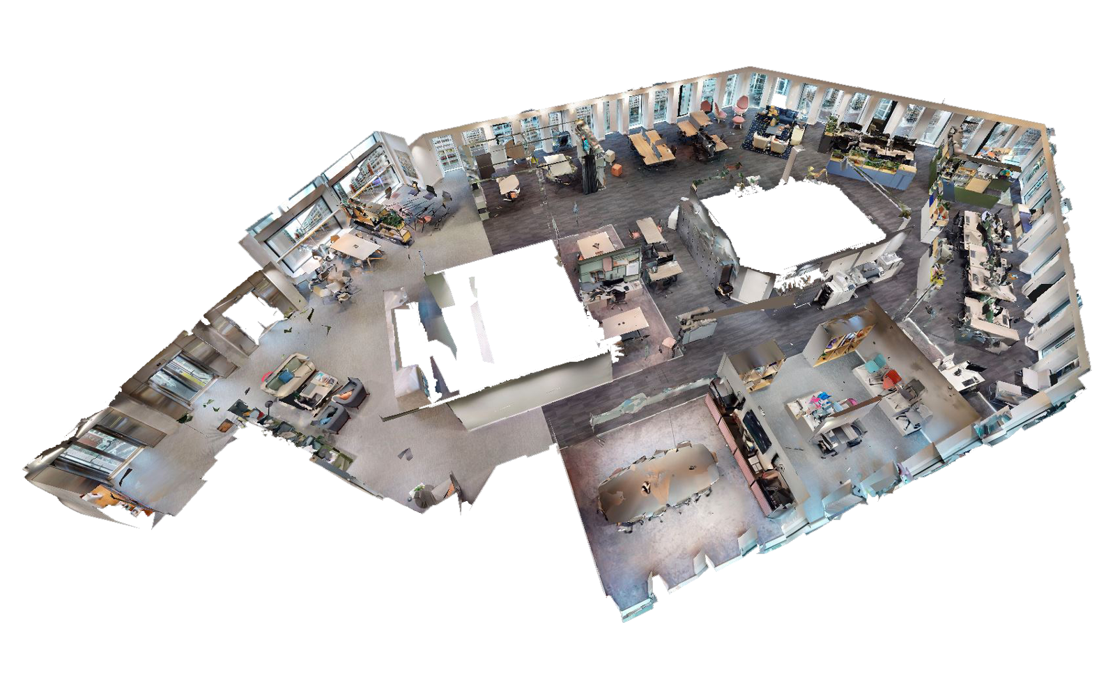
While BIM provides technical insight, tools like Matterport bring accessibility and visual clarity. These 3D virtual walkthroughs allow clients, contractors, and stakeholders to ‘visit’ a building remotely, view measurements, tag important elements, and plan activities without needing to be on site.

This is particularly valuable in high-risk or high-traffic environments such as hospitals, industrial plants, or busy retail estates. With a virtual tour of a building or environment, site inductions, safety briefings, and stakeholder reviews can all happen off-site—saving time, reducing disruption, and improving health and safety.

And because Matterport scans can be integrated with BIM and survey data, the result is a holistic digital toolkit that supports better decision-making across the building’s lifecycle.

Laser Scanning Buildings BIM Revit Models Matterport

Practical Applications Across Sectors

This integrated approach to building data isn’t just theoretical—it’s already proving invaluable on live projects across the UK.

Take urban redevelopment: a measured building survey can inform demolition strategies by showing which parts of a structure can be safely retained. In one project at the Broadwalk Shopping Centre in Bristol, Platinum 3D’s initial 2D plans were so precise that when the client later requested a 3D Revit model of the basement, it could be produced immediately from existing scan data—avoiding a return visit and keeping timelines on track.

In heritage restoration, as with Adelaide House near London Bridge, laser scanning captures intricate façade details and asymmetries that manual methods could easily miss. These are then translated into BIM models that balance conservation with modern design needs—allowing teams to restore what matters while confidently upgrading what’s needed.

In hospitals, such as the Royal Gwent in Newport, a phased laser scan and modelling programme allowed architects to plan department refurbishments while facilities teams used the same BIM data to manage ongoing maintenance and compliance.

Why Choose Platinum 3D?

At Platinum 3D Consultants, we don’t just deliver surveys—we provide the complete digital foundation that modern projects depend on. From the initial scan to the final model, every output is crafted in-house by our experienced team using proven, best-in-class technology.

We’ve worked with clients across commercial, heritage, healthcare, industrial, and public sectors—each with their own challenges, priorities, and ambitions. What they all have in common is a need for clarity, consistency, and confidence in the data that drives their decisions.

By combining accurate measurement with intelligent modelling and immersive visualisation, we help our clients reduce risk, save time, improve communication, and deliver better buildings.

Ready to Work Smarter?

If you’re planning a refurbishment, redevelopment, or large-scale maintenance programme and want to start with the right information, get in touch with Platinum 3D Consultants.

From site to screen, we’re here to help you see the full picture—and make it work for you.

How Laser Scanning and BIM Models Help Architects and FM Teams Alike

laser scan surveys BIM ready Revit models Royal Gwent Hospital

For architects and facilities managers working with complex sites such as hospitals, gaining a clear, accurate understanding of a building’s structure and systems is vital. Whether planning a refurbishment, redesigning internal layouts, or managing ongoing maintenance, reliable data is the foundation for good decision-making.

That’s where laser scanning and BIM-ready Revit models come in. These digital tools bridge the gap between design and day-to-day operations — providing architects with the detailed models they need for planning, while giving facilities teams the insights and structure required to manage large estates with precision.

At Platinum 3D Consultants, we’ve helped numerous clients achieve this clarity. One recent example is our work at the Royal Gwent Hospital in Newport, Wales, where a series of phased refurbishments made precision and coordination a top priority.

Royal Gwent Hospital Laser Scanning

From Site to Model: Supporting Design and Refurbishment

The Royal Gwent Hospital is undergoing a programme of maintenance and modernisation across several departments. Working closely with the architectural design team, we carried out comprehensive laser scanning of key areas across the site.

The scanning process involved installing a control network to ensure all surveys — including those conducted at later phases — would align precisely with each other. This is particularly important in large-scale, multi-phase projects like this, where works can span several months or even years.

Our scans captured every architectural detail, from structural elements and internal layouts to mechanical and electrical services. These were processed into high-quality, geometrically accurate point clouds, which then formed the basis of BIM-ready Revit models.

These models provide a shared, central reference point for the architects leading the design, ensuring they can plan effectively, identify potential constraints, and integrate new layouts confidently within the existing fabric of the building.

Enabling Facilities Management with the Same Data

While architects benefit from the clarity of Revit models for design and documentation, the same data can be a powerful asset for facilities managers. At the Royal Gwent Hospital, our models are being used not only for the immediate design works but also to support ongoing maintenance and compliance.

The models can include details such as plant room layouts, access points, service routes, and fire safety equipment — all mapped with precision and tied to a common digital framework. This allows FM teams to plan maintenance schedules, run condition audits, and even simulate upgrades with minimal disruption.

Because the data is digital and scalable, clients can use it to link with other asset management systems or import it into a wider estate-wide digital strategy. This brings consistency across departments and gives estates teams a powerful tool for improving long-term building performance.

Laser Scanning

Trusted Digital Partners for Complex Environments

At Platinum 3D Consultants, we understand that every project is different — especially when it comes to live environments like hospitals. That’s why we tailor each model to the specific requirements of the client, whether that means coordinating multiple departments during phased refurbishments, supporting a team of architects with detailed technical modelling, or enabling facilities teams to manage an estate that evolves over time.

Because we handle all scanning, modelling, and Revit development in-house, we ensure a seamless workflow from site to screen. This also means we can be highly responsive to client needs — for example, producing new floor plans, elevations, or asset extracts from the original point cloud data without needing to return to site. That’s exactly what we did at Royal Gwent when additional models were required for a new phase of work.

A Forward-Looking Approach to Building Information

The success of any digital project lies in planning for the long term. The models we deliver today don’t just serve immediate construction or refurbishment needs — they provide a foundation for future improvements, upgrades, and better decision-making throughout the lifecycle of the building.

When paired with facilities management platforms or integrated into a wider digital estate strategy, our BIM-ready Revit models support:

  • Predictive maintenance, by embedding lifecycle data
  • Compliance tracking, by mapping fire safety routes and service locations
  • Space planning and asset audits, especially across healthcare estates
  • Future developments, thanks to the ability to build on verified existing conditions

With the rising demand for sustainability, energy efficiency, and smart building capabilities, having a well-structured digital record of your estate is becoming essential — and it all starts with accurate measurement and professional modelling.

Let’s Talk About Your Next Project

If you’re responsible for designing, upgrading, or managing complex buildings — especially those in the healthcare, heritage, education, or commercial sectors — a professionally delivered laser scanning and BIM modelling service can change how you work. With the right digital tools, you can reduce risks, avoid costly delays, improve collaboration, and gain long-term clarity over your estate.

At Platinum 3D Consultants, we are proud to be at the forefront of digital survey and modelling services in the UK. We work with architects, estate teams, developers, and contractors across the country to deliver reliable, accurate, and intelligent models that support better outcomes — from initial planning through to long-term management.

We’re always happy to talk through your requirements, demonstrate what’s possible, and show how similar projects have benefited from our support.

📞 Get in touch today to find out how our laser scanning and BIM services can enhance your next project – and unlock the true value of your built environment.

How Scan to BIM and Laser Surveying Enable Renovation of Historic Buildings

Adelaide house laser scan survey Scan to BIM Revit model

Renovating historic or listed buildings comes with a unique set of challenges. Balancing the protection of architectural heritage with the needs of modern users requires careful planning, precise information, and highly specialised expertise. When the aim is to preserve a listed façade while completely updating the interior to meet modern standards, accurate survey data and 3D modelling become essential.

At Platinum 3D Consultants, we bring together laser scanning, point cloud processing, and Building Information Modelling (BIM) to support the restoration and repurposing of the UK’s most iconic buildings. Our recent work on Adelaide House, a Grade II listed skyscraper next to London Bridge, highlights just how important these tools have become in 21st-century renovation projects.

Adelaide house laser scan survey Scan to BIM Revit model

Meeting the Challenges of Renovating a Listed Building

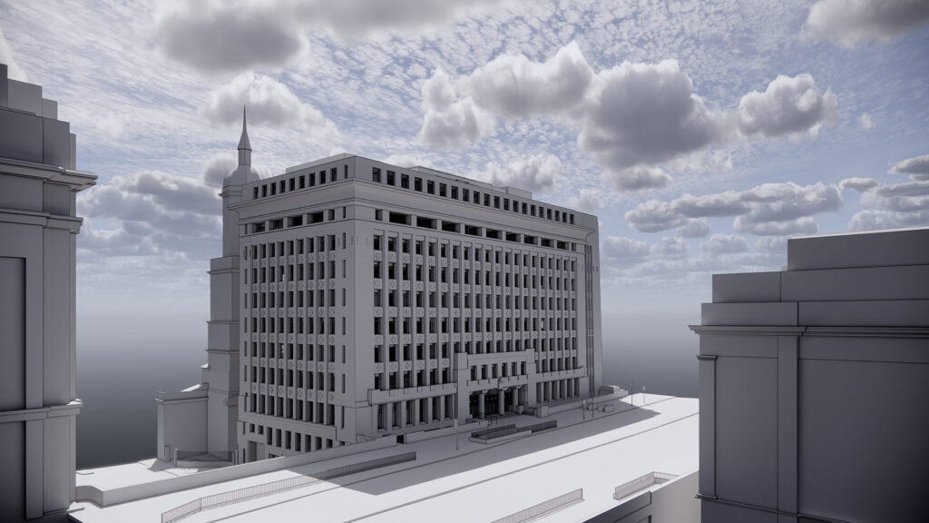
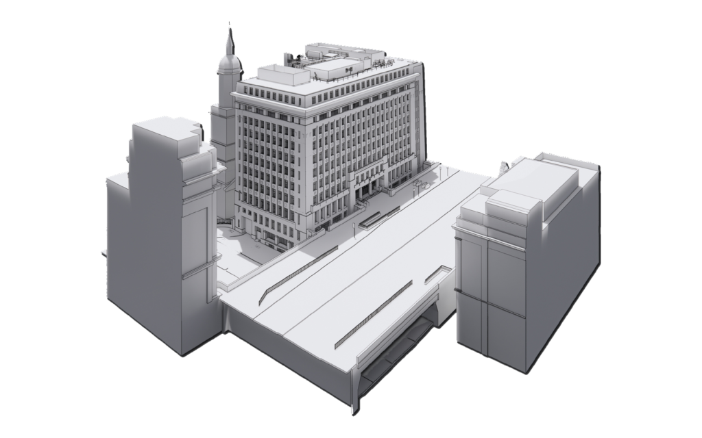
Built between 1920 and 1925 and influenced by the skyscrapers of Chicago, Adelaide House is a pioneering structure in London’s architectural history. The 11-storey office building features a steel frame, unique Crittall windows, and subtly tapered walls – all of which required accurate capture and modelling during its modernisation.

The client’s brief involved maintaining the heritage-listed exterior, while renovating the entire interior to meet the expectations of today’s commercial tenants. This is exactly where a full laser scan survey and Scan to BIM model become not just helpful, but absolutely vital.

Laser Scanning: Capturing the Built Reality in Precise Detail

Platinum 3D began by conducting a comprehensive laser scan survey of the entire structure. Laser scanning captures millions of data points per second, building up a millimetre-accurate digital replica (known as a point cloud) of every structural and architectural element.

This scan included:

  • The full building exterior and interior
  • A detailed lift shaft survey
  • The service passage and junction with London Bridge
  • Adjoining structures and the surrounding urban context

Once scanned, this data was processed into an accurately registered point cloud, aligned to a known coordinate system. This forms the base for every design and planning decision that follows.

scan to BIM

Scan to BIM: Turning Survey Data into a Powerful Planning Tool

From this point cloud, our team created a Scan to BIM model using Autodesk Revit. For Adelaide House, we delivered a Level of Detail 3 (LOD3) model of the building itself and LOD2 models of the surrounding buildings and bridge to provide essential planning context.

Why does this matter? An LOD3 model includes:

  • All architectural and structural elements, from columns and beams to façade details
  • Parametric families for repeatable components, such as Crittall windows
  • Accurate modelling of irregular features, such as the uniquely tapered external walls
  • Fully structured model data, suitable for use in planning, coordination, and facility management

This allows the design team to fully understand the building before making any interventions – reducing risk and enabling better decisions at every stage.

Modelling Complex Features with Confidence

Listed buildings often come with geometric quirks. For Adelaide House, the front and side elevations featured tapered walls and columns – each one slightly different. Our in-house team worked closely with the client to ensure these were modelled accurately and efficiently.

We created custom wall families with sloped profiles, avoiding time-consuming in-place modelling while preserving the flexibility to schedule and quantify each type.

Similarly, the distinct Crittall windows, which varied across the façade, were modelled using bespoke family templates from our extensive component library – ensuring both visual fidelity and Revit compatibility.

The Benefits for the Project Team

Platinum 3D’s combination of services delivered more than just technical drawings. It provided a digital foundation for the entire renovation process, enabling the project team to:

  • Retain and protect the listed façade while modernising the interior
  • Coordinate services and structure in a confined, complex layout
  • Ensure planning compliance using accurate models of the surrounding context
  • Streamline design and construction phases through clash detection and visualisation
  • Enable remote collaboration, reducing the need for repeated site visits

All of this, delivered with a clear specification, ongoing communication, and a responsive in-house team that understands the pressures of real-world renovation.

Why Choose Platinum 3D for Your Heritage Renovation?

Renovating historic or listed buildings is not a one-size-fits-all process. It demands a tailored approach that respects the character of the original architecture while unlocking its potential for modern use.

At Platinum 3D Consultants, we combine cutting-edge technology with decades of experience to deliver:

  • High-precision laser scanning
  • Registered point cloud generation
  • Scan to BIM modelling in Revit, with options for LOD2, LOD3 and beyond
  • Bespoke family creation for architectural details
  • Survey-to-model workflows that reduce cost, time, and risk

We’ve helped clients across London and the UK modernise complex, historically significant structures without compromise – providing digital tools that make informed renovation possible.

Talk to the Experts

Whether you’re renovating a Grade II listed office block or repurposing a disused industrial site, we can help. Our laser scanning and BIM services provide the digital clarity needed to guide every decision from planning through to completion.

Get in touch with Platinum 3D Consultants today to find out how we can support your renovation project with detailed surveys, accurate 3D models, and a service that’s built around your goals.

The Complete Digital Toolkit: How Measured Surveys, BIM & Virtual Reality Are Revolutionising the Built Environment

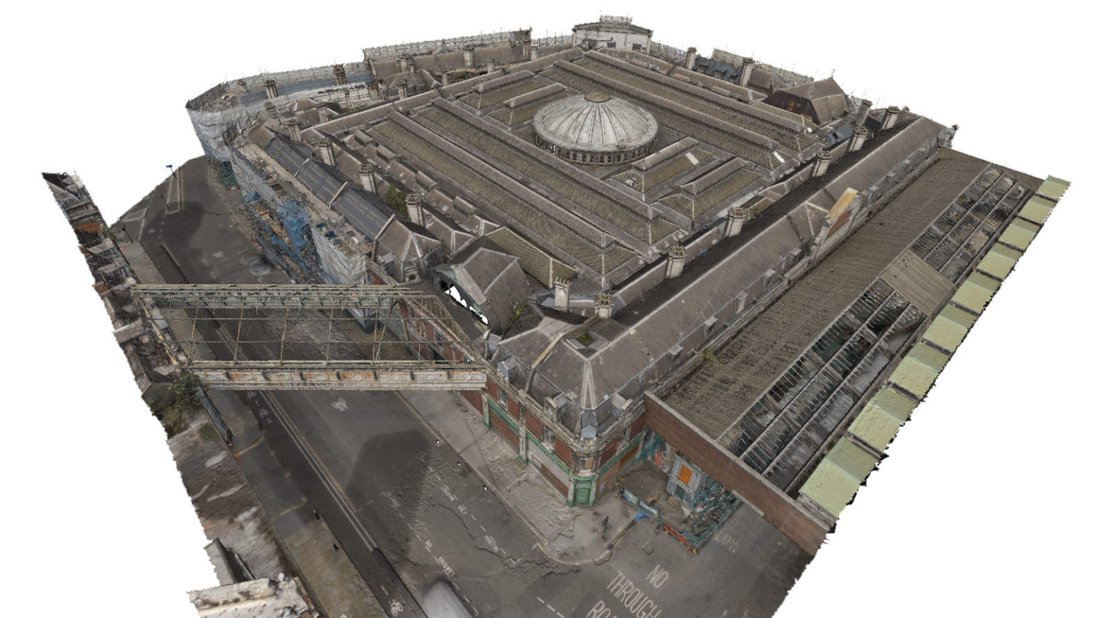
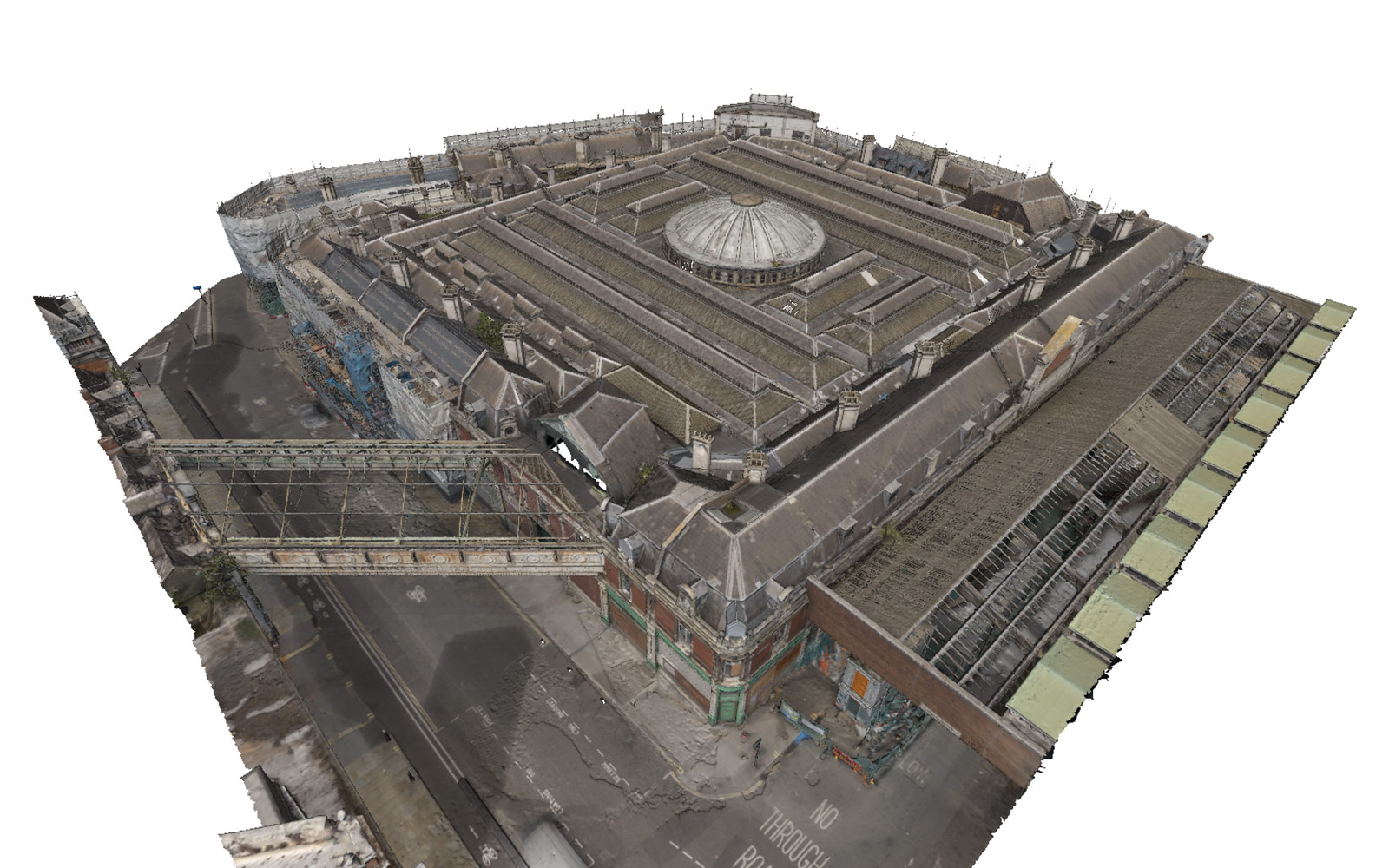
Smithfield Market renovation works laser scanning and aerial photogrammetry

The construction, architecture, and property industries are undergoing a digital revolution. Advanced surveying methods, 3D modelling, and virtual reality are transforming how buildings are designed, built, and managed. Technologies such as measured surveys, laser scanning, Building Information Modelling (BIM), and Matterport virtual tours are reshaping the way professionals interact with and understand the built environment.

At Platinum 3D Consultants, we specialise in capturing, modelling, and digitising buildings using the latest reality capture technologies. By integrating these tools, we help architects, engineers, contractors, and property managers work more efficiently, reduce errors, and improve project outcomes. This article explores how these technologies fit together and the value they bring to the industry.

measured building surveying and laser scanning

What Are Measured Surveys and Why Are They Essential?

A measured survey is a precise method of collecting data about a building or site. Unlike traditional surveys, which rely on manual measurements, modern measured surveys use laser scanning to capture highly detailed and accurate 3D spatial data. These surveys create a digital representation of an existing structure, which can be used for renovation, redevelopment, and facility management.

Measured surveys are particularly valuable for:

  • Architects and designers, who require exact dimensions before starting a project.
  • Contractors, who need precise information to avoid costly mistakes.
  • Building owners and facility managers, who need accurate records for maintenance and compliance.

Using laser scanners, Platinum 3D Consultants can collect millions of data points per second, creating point clouds that provide an incredibly detailed view of a building’s physical characteristics. These point clouds then form the foundation for BIM models, CAD drawings, and 3D visualisations.

How BIM Takes Measured Survey Data to the Next Level

Building Information Modelling (BIM) is the process of creating intelligent 3D models that contain not just geometry but also metadata about materials, building elements, and performance metrics. BIM allows professionals to collaborate effectively, make data-driven decisions, and improve efficiency at every stage of a building’s lifecycle.

Key Benefits of BIM in Construction and Design:

  • Improved collaboration – Teams can access and edit the same digital model, ensuring consistency across disciplines.
  • Fewer errors and rework – BIM’s ability to identify clashes between building elements (e.g., pipes conflicting with structural beams) prevents costly mistakes.
  • Streamlined project management – With a clear digital record, project managers can track progress and plan efficiently.
  • Better sustainability and cost control – BIM allows for energy performance analysis, material tracking, and lifecycle cost calculations.

At Platinum 3D Consultants, we create BIM-ready Revit models from our measured building survey data, ensuring accuracy and consistency for architects, engineers, and developers. Whether working on heritage building restoration, commercial developments, or infrastructure projects, BIM provides a solid foundation for smart decision-making.

laser scanning stadium

Matterport Virtual Tours: Bringing Spaces to Life

Matterport virtual tours are transforming the way professionals interact with built environments. By creating immersive 3D models, Matterport allows stakeholders to explore buildings remotely, make informed decisions, and reduce the need for on-site visits.

How Matterport Virtual Tours Add Value:

  • Remote collaboration – Clients, designers, and contractors can experience a property from anywhere, reducing travel costs and project delays.
  • Enhanced safety – For high-risk environments (e.g., construction sites or hazardous industrial facilities), virtual site visits minimise unnecessary exposure.
  • Streamlined planning and communication – Virtual walkthroughs help ensure that all stakeholders have a shared understanding of site conditions before work begins.

By integrating Matterport scans with measured surveys and BIM, Platinum 3D Consultants offers a complete digital toolkit, making site data more accessible, interactive, and actionable.

How These Technologies Fit Together for Maximum Efficiency

When used together, measured surveys, BIM, and Matterport virtual tours create a powerful workflow that streamlines every phase of a project:

  1. Measured Surveys Capture the Reality

    • Laser scanning collects highly accurate data on-site.
    • Creates 3D point clouds and 2D CAD drawings for further processing.
  2. BIM Converts Data into a Smart Model

    • Point cloud data is processed into BIM-ready Revit models.
    • Enables clash detection, planning, and collaboration across teams.
  3. Matterport Virtual Tours Provide Remote Access

    • Stakeholders can walk through a digital version of the building from anywhere.
    • Supports pre-construction planning, training, and maintenance strategies.

Why Choose Platinum 3D Consultants?

At Platinum 3D Consultants, we provide expert measured building surveys, laser scanning, BIM modelling, and Matterport virtual tours. Our team is dedicated to delivering geometrically accurate, high-quality digital models that help our clients make informed decisions, reduce risk, and improve efficiency.

By integrating the latest technology into our workflow, we ensure that your project benefits from precision, accuracy, and innovation at every stage. Whether you’re an architect, developer, contractor, or property manager, we offer solutions tailored to your needs.

Get in Touch Today

If you’re looking to enhance your building design, construction, or facility management process with the latest digital surveying and modelling technology, contact Platinum 3D Consultants today. Our expertise in measured surveys, BIM, and Matterport virtual tours ensures that you get the most accurate, efficient, and innovative solutions available.

📞 Contact us now to discuss your project and see how our complete digital toolkit can transform the way you work!

A Real Example of a 3D Survey – The Natural History Museum in London

natural history museum 3D building survey

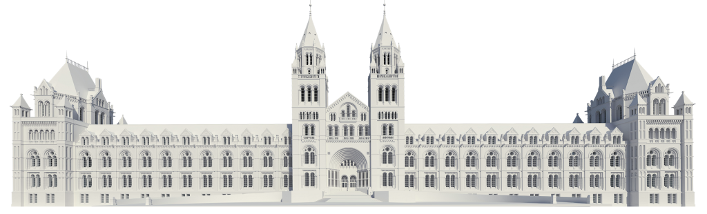
The Natural History Museum in London is one of the UK’s most iconic cultural institutions. Housing millions of artefacts and attracting visitors from around the globe, this historic building is as much a wonder as the exhibits it contains. Managing a site of this size and complexity requires cutting-edge solutions, which is why the Museum turned to Platinum 3D Consultants for a comprehensive 3D survey and BIM-ready Revit modelling.

This project demonstrates the transformative power of 3D surveys, showcasing how precise data collection and advanced modelling can enhance the management, renovation, and future-proofing of complex heritage sites.

natural history museum

What Was Done?

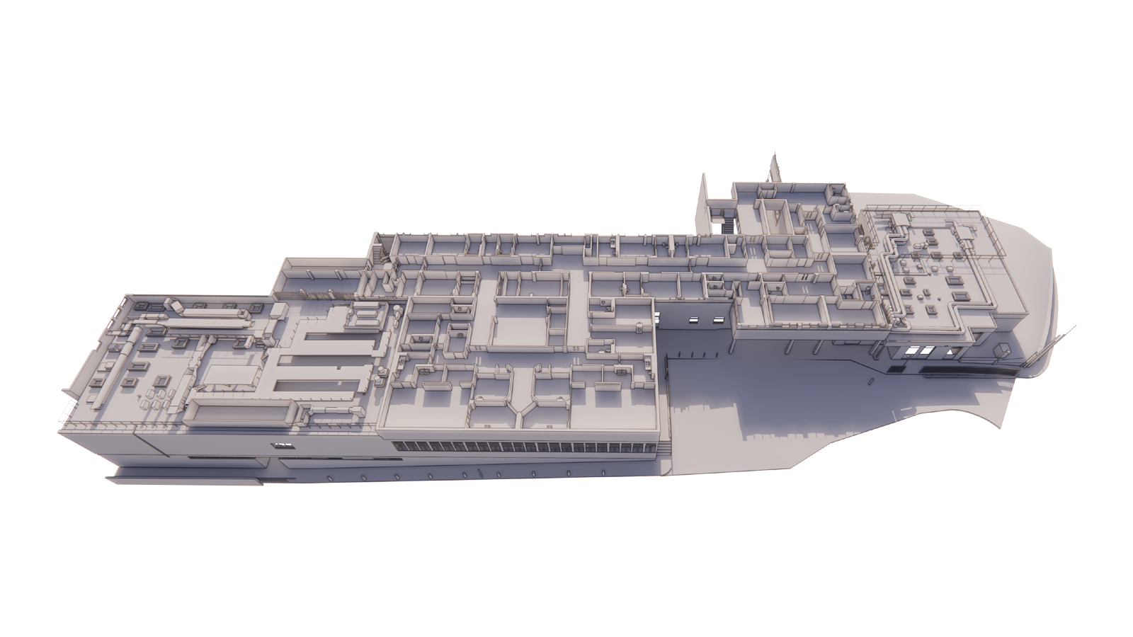
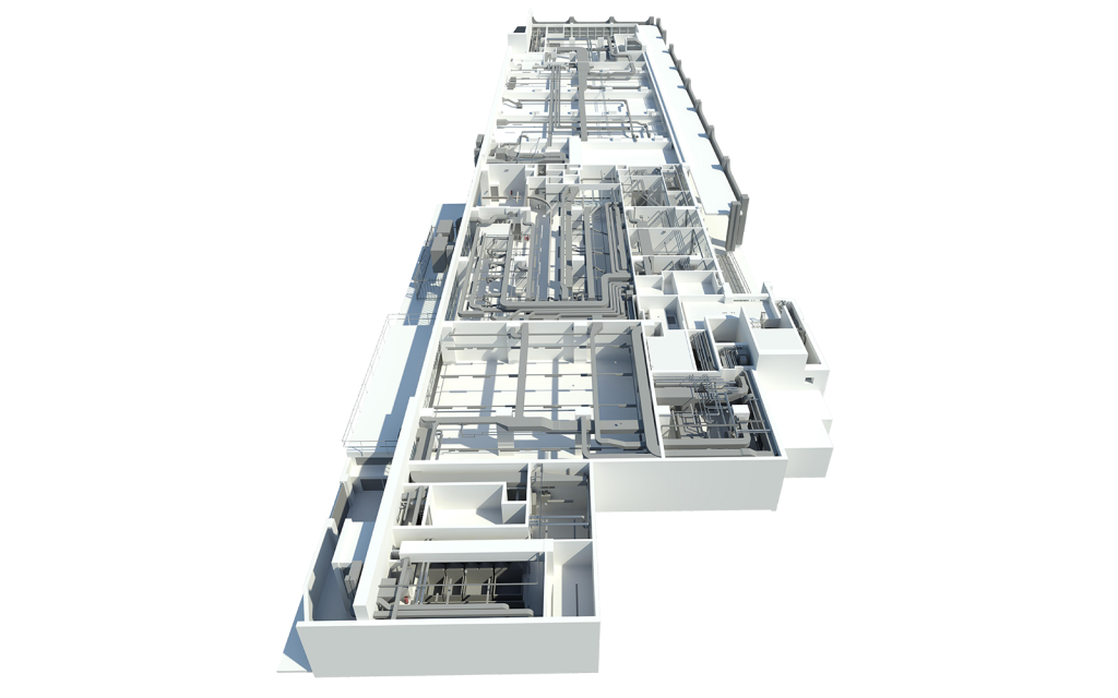
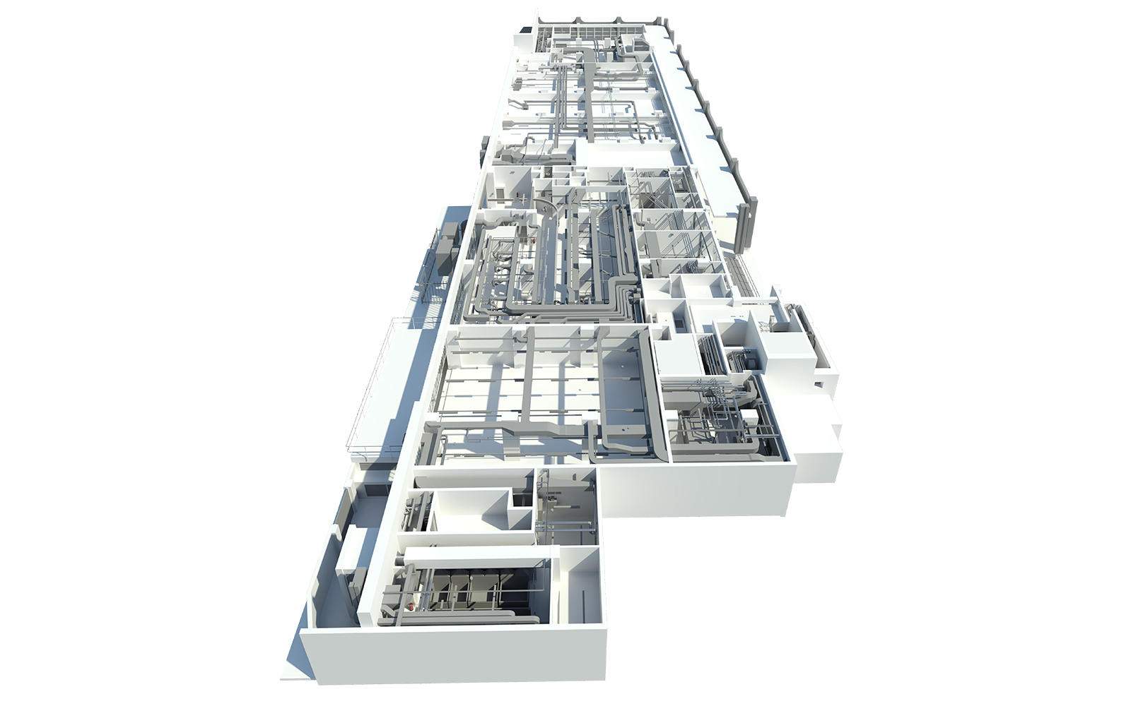
Platinum 3D Consultants were engaged to survey and model several key locations within the Natural History Museum estate. The project included creating LOD3 models (Level of Detail 3), which captured extensive architectural and mechanical details, including:

  • Piping and ducting systems.
  • Lighting, switches, and sockets.
  • Detailed layouts of laboratories and plant rooms, which posed unique challenges due to their intricate infrastructure.

The models were designed to be geo-referenced, ensuring that all components were aligned within the same coordinate system. This unified approach allows for seamless integration into a single master project, enhancing the Museum’s ability to manage its estate collaboratively and efficiently.

You can watch a video about our work for the Natural History Museum in the Case Studies section of our website here.

How Was It Done?

The project required a meticulous approach, combining state-of-the-art technology with expertise in heritage surveying:

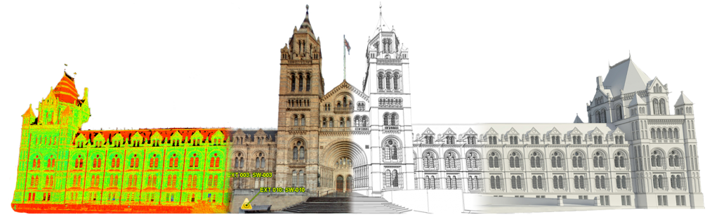
1. Laser Scanning

Using high-precision laser scanning technology, Platinum 3D captured millions of data points per second. This non-invasive method allowed the team to record every visible detail of the Museum’s infrastructure, including its complex mechanical and electrical systems.

2. Point Cloud Data Processing

The captured data was processed into a dense point cloud, providing an exact digital representation of the surveyed areas. This point cloud formed the foundation for creating the 3D models.

3. Revit Modelling

Using Scan to BIM techniques, the point cloud data was converted into BIM-ready Revit models. The models included detailed architectural elements and mechanical systems, adhering to LOD3 standards to meet the Museum’s requirements.

4. Geo-Referencing

All models were geo-referenced, ensuring that every element was positioned accurately within a global coordinate system. This step was crucial for integrating the data into the Museum’s overarching estate management strategy.

Why Was It Done?

The Natural History Museum embarked on this project as part of its broader strategy to prioritise digital transformation and innovation. The 3D survey and Revit models served several critical purposes:

  1. Streamlining Estate Management
    The Museum’s vast estate includes multiple buildings and intricate infrastructure. The BIM-ready models provide a single source of truth, enabling the Museum to manage its facilities more efficiently.
  2. Enhancing Collaboration
    Geo-referenced models allow multiple stakeholders, including architects, engineers, and facility managers, to collaborate effectively using the same data-rich platform.
  3. Supporting Renovation and Maintenance
    Detailed 3D models simplify planning for renovations or upgrades, particularly in complex areas such as laboratories and plant rooms. The accuracy of the models reduces the risk of costly errors or rework.
  4. Preserving Heritage
    By documenting the existing infrastructure with precision, the Museum ensures that its historical integrity is preserved while supporting modernisation efforts.
  5. Enabling Future Planning
    The models form the basis for ongoing digital initiatives, including further integration of Building Information Modelling (BIM) as a powerful tool for information management.
natural history museum

The Value of This Work

1. Unmatched Accuracy

The laser scanning process captured every detail of the Museum’s complex systems, ensuring that nothing was overlooked. This level of accuracy supports decision-making and prevents costly mistakes during renovations or maintenance.

2. Efficiency and Cost Savings

By providing a digital twin of the Museum’s estate, the 3D models eliminate the need for repeated site visits, saving time and resources. Maintenance teams can access detailed information remotely, streamlining their work.

3. Future-Proofing

The project aligns with the Museum’s vision for digital transformation. The data-rich BIM models provide a foundation for integrating future technologies, such as smart building systems, ensuring the estate remains adaptable and efficient.

4. Improved Collaboration

The geo-referenced models enable seamless collaboration across departments and with external contractors, enhancing project coordination and reducing the risk of miscommunication.

How Platinum 3D Consultants Deliver Value

At Platinum 3D Consultants, we specialise in using the latest reality capture technology to create accurate 3D models for complex projects. Our services include:

  • Laser Scanning: Capturing precise data with millimetre accuracy.
  • Measured Building Surveys: Delivering detailed plans, elevations, and sections to suit your needs.
  • Scan to BIM: Producing BIM-ready Revit models tailored to your project requirements.
  • Geo-Referencing: Ensuring data consistency and spatial accuracy across projects.

Our experience working on heritage sites, such as the Natural History Museum, demonstrates our ability to balance the demands of modernisation with the need for preservation.

Talk To Platinum 3D Consultants

The Natural History Museum project highlights the immense value of 3D surveys and BIM-ready modelling in managing complex estates. By partnering with Platinum 3D Consultants, the Museum has gained a powerful tool to streamline operations, support collaboration, and future-proof its facilities while preserving its historic character.

If you’re managing a complex estate or planning a significant renovation, contact Platinum 3D Consultants today. Let us show you how our expertise in 3D surveys can transform your project and deliver exceptional results.

How Do 3D Digital Models Improve Facility Management?

3D digital models from laser scanning

Effective facility management is critical for maintaining the functionality, safety, and efficiency of buildings. With the increasing complexity of modern facilities, managing assets, optimising space, and planning maintenance can become overwhelming. This is where 3D digital models, especially those created through Building Information Modelling (BIM), revolutionise facility management.

At Platinum 3D Consultants, we specialise in creating accurate, data-rich 3D models from detailed measured building surveys and laser scanning. These models provide a comprehensive digital twin of your building, enabling better decision-making, streamlined operations, and long-term cost savings.

In this blog, we’ll explore how 3D digital models transform facility management and how Platinum 3D’s services make this transformation seamless.

measured building surveying and laser scanning

The Challenges of Facility Management

Facility managers are responsible for overseeing a wide range of tasks, from day-to-day operations to long-term maintenance planning. Without accurate and up-to-date data, they face several challenges:

  1. Inaccurate or Outdated Building Information
    Buildings often lack comprehensive documentation, particularly if they’ve undergone multiple renovations. Relying on outdated blueprints can lead to errors and inefficiencies.
  2. Complex Building Systems
    Managing HVAC, plumbing, electrical, and structural systems in large facilities can be a daunting task without a clear understanding of their layout and connections.
  3. Space Optimisation
    Efficiently allocating and managing space within a facility is crucial for reducing costs and improving productivity. Without accurate data, this process can be guesswork.
  4. Maintenance Planning
    Scheduling repairs and upgrades without disrupting operations requires detailed knowledge of building systems and their current conditions.

How 3D Digital Models Address These Challenges

A 3D digital model acts as a digital twin of your facility, providing a centralised, data-rich platform for managing every aspect of the building. Here’s how these models improve facility management:

1. Accurate and Centralised Building Data

One of the primary benefits of 3D models is the consolidation of all building information into a single, accessible format. This eliminates the need to rely on scattered documents or outdated plans.

  • What We Do at Platinum 3D:
    Using laser scanning, we capture the existing conditions of your building with millimetre accuracy. This data is converted into a BIM-ready Revit model, which includes all architectural, structural, and mechanical details.
  • Benefits:
    • Instant access to precise data for every part of the building.
    • Streamlined communication across teams using a unified model.

2. Visualisation of Building Systems

Managing a building’s systems—HVAC, plumbing, electrical, and more—becomes significantly easier with a 3D model. These systems can be layered within the model, allowing facility managers to visualise how they connect and interact.

  • What We Do at Platinum 3D:
    Our models incorporate detailed layouts of mechanical and electrical systems, helping facility managers plan maintenance and identify potential issues without needing on-site inspections.
  • Benefits:
    • Quick identification of system locations and connections.
    • Reduced risk of accidental damage during repairs or upgrades.

3. Efficient Space Management

Space optimisation is crucial for reducing operational costs and enhancing productivity. 3D models provide accurate measurements and layouts, enabling facility managers to make informed decisions about how to allocate and use space.

  • What We Do at Platinum 3D:
    Our measured building surveys produce precise floor plans and area referencing, ensuring that every square metre of your building is accounted for.
  • Benefits:
    • Improved space utilisation based on accurate data.
    • Easier planning for expansions or reconfigurations.
laser scanning stadium

4. Proactive Maintenance and Asset Tracking

With a digital twin of your facility, maintenance becomes proactive rather than reactive. Facility managers can track the condition of assets, schedule repairs, and plan upgrades before issues arise.

  • What We Do at Platinum 3D:
    Our 3D models include metadata about building components, such as material specifications, installation dates, and maintenance schedules.
  • Benefits:
    • Reduced downtime through planned maintenance.
    • Longer lifespan for building systems due to timely interventions.

5. Clash Detection and Risk Mitigation

During renovations or upgrades, it’s common for new designs to clash with existing structures or systems. 3D models allow facility managers to identify these conflicts early, avoiding costly on-site adjustments.

  • What We Do at Platinum 3D:
    Our Scan to BIM process includes clash detection capabilities, ensuring that new installations integrate seamlessly with existing systems.
  • Benefits:
    • Fewer project delays and cost overruns.
    • Safer renovations with reduced risk of structural damage.

6. Future-Proofing with Digital Twins

A 3D digital model isn’t just a tool for current operations—it’s an investment in your building’s future. These models serve as a long-term resource, supporting ongoing facility management and future renovations.

  • What We Do at Platinum 3D:
    We create geo-referenced models that align with real-world coordinates, ensuring seamless integration with future technologies and projects.
  • Benefits:
    • Easy integration of renewable energy systems or smart building technologies.
    • Long-term cost savings through informed decision-making.

How Platinum 3D Consultants Support Facility Managers

At Platinum 3D Consultants, we offer a range of services designed to empower facility managers with the tools they need to succeed:

  • Laser Scanning: Capturing millimetre-accurate data for even the most complex facilities.
  • Measured Building Surveys: Providing detailed plans, elevations, and sections to RICS standards.
  • Scan to BIM: Creating BIM-ready Revit models for seamless integration into facility management systems.
  • Geo-Referenced Models: Ensuring spatial accuracy for large or multi-building sites.

By combining these services, we deliver reliable, data-rich models that form the backbone of effective facility management.

Real-World Applications of 3D Digital Models

Case Study: A Commercial Office Complex
One of our clients needed to optimise space usage across a large office building. Using laser scanning and BIM modelling, we provided accurate floor plans and a detailed layout of the building’s HVAC and electrical systems. The client used this data to reconfigure office spaces, reduce energy consumption, and plan future upgrades without disrupting daily operations.

Case Study: A Historic Museum
For a heritage site, we created a 3D model that documented every architectural detail while also integrating modern building systems. Facility managers used the model to plan maintenance, monitor structural integrity, and ensure compliance with preservation regulations.

Talk To Platinum 3D Consultants

3D digital models are transforming the way buildings are managed, offering unparalleled accuracy, efficiency, and long-term value. From streamlining maintenance to optimising space, these models provide facility managers with the insights they need to make informed decisions and achieve operational excellence.

At Platinum 3D Consultants, we specialise in creating accurate, data-rich models tailored to your building’s unique needs. Whether you’re managing a modern office, a historic landmark, or a complex industrial facility, our services ensure that you have the tools to succeed.

Contact us today to learn how our 3D digital modelling services can transform your facility management strategy. Let’s build a smarter, more efficient future for your building.

Can 3D Modelling Help Bridge the Gap Between Design and Construction Teams?

3D modelling buildings environments

In the fast-paced world of construction, ensuring seamless collaboration between design and construction teams is crucial to the success of any project. Miscommunication, conflicting priorities, and inaccuracies in project data can lead to costly delays, rework, and frustration. This is where 3D modelling, particularly through Building Information Modelling (BIM), has become a game-changer. By creating detailed, data-rich models, 3D technology provides a shared platform that improves communication, reduces errors, and streamlines workflows.

At Platinum 3D Consultants, we specialise in bridging the gap between design and construction teams through advanced Scan to BIM, laser scanning, and measured building surveys. In this blog, we’ll explore how 3D modelling facilitates better collaboration, the unique benefits it offers, and how our services make it all possible.

Building Measurement 3D Modelling Laser Scanning

The Disconnect Between Design and Construction Teams

Traditionally, design and construction teams have often worked in silos, each focusing on their own priorities and processes. This disconnect can lead to several challenges:

  1. Miscommunication: Design teams often produce complex drawings that construction teams may interpret differently, leading to errors on-site.
  2. Inaccurate or Incomplete Data: Traditional methods of sharing project details may miss key measurements or structural considerations, causing clashes during construction.
  3. Lack of Real-Time Updates: Without a unified system, any changes to the design during construction may not be communicated effectively to all stakeholders, resulting in confusion and delays.

These challenges underscore the need for a shared platform that aligns all teams, improves accuracy, and enables real-time collaboration. This is where 3D modelling steps in.

How 3D Modelling Bridges the Gap

3D modelling provides a unified, visual representation of the project, accessible to both design and construction teams. It serves as a single source of truth, fostering collaboration and reducing errors. Here’s how it works:

1. Creating a Shared Platform with BIM

At Platinum 3D Consultants, we use Building Information Modelling (BIM) to create data-rich digital models that integrate architectural, structural, and mechanical systems into a cohesive design. These models go beyond simple visualisation—they include detailed data on materials, dimensions, and systems, making them a valuable tool for construction teams.

Key Benefits of BIM:

  • Provides a clear visualisation of the project for all stakeholders.
  • Enables clash detection, identifying potential conflicts between systems before construction begins.
  • Offers real-time updates, ensuring that any changes to the design are instantly reflected and accessible to all teams.

2. Accurate Data Through Laser Scanning

Our laser scanning services ensure that every measurement and detail of the existing environment is captured with millimetre precision. This level of accuracy eliminates guesswork and ensures that both design and construction teams have reliable data to work from.

measured building surveying and laser scanning

How Laser Scanning Helps Collaboration:

  • Captures as-built conditions for renovation or extension projects.
  • Produces dense point clouds, which are converted into BIM-ready models for seamless integration.
  • Reduces the need for repeated site visits by capturing comprehensive data in a single session.

3. Seamless Translation with Scan to BIM

Scan to BIM is the process of converting laser-scanned point cloud data into Revit models that are ready for collaborative use. At Platinum 3D Consultants, we specialise in creating geometrically accurate Revit models that include all the details needed for construction.

Advantages of Scan to BIM:

  • Ensures that all project stakeholders work from the same precise digital model.
  • Provides a clear framework for planning, coordination, and construction.
  • Supports clash detection, allowing teams to identify and resolve issues early in the process.

4. Real-Time Updates and Collaboration

One of the most significant advantages of 3D modelling is the ability to make real-time updates. Changes made to the model are instantly reflected across all systems, ensuring that both design and construction teams are always working with the latest information.

At Platinum 3D Consultants, our geo-referenced models are designed to integrate seamlessly into a master coordinate system, enabling collaborative workflows across large or complex projects. This approach ensures spatial accuracy, reduces errors, and improves project efficiency.

Unique Benefits of 3D Modelling for Collaboration

1. Enhanced Communication

3D models provide a visual representation that’s easy for all stakeholders to understand, regardless of their technical background. This fosters better communication between teams and ensures that the design intent is clear.

2. Reduced Errors and Rework

By using detailed models that integrate all building systems, potential conflicts are identified and resolved before construction begins. This reduces errors, minimises rework, and keeps projects on schedule.

3. Improved Decision-Making

With all project data consolidated into a single model, stakeholders can make informed decisions based on accurate and up-to-date information. This ensures that resources are allocated effectively and risks are mitigated.

4. Cost and Time Savings

Accurate data, real-time updates, and streamlined collaboration significantly reduce project timelines and costs. Teams can avoid costly mistakes and delays, ensuring that the project stays within budget.

Real-World Applications of 3D Modelling

At Platinum 3D Consultants, we’ve seen first-hand how 3D modelling improves collaboration in complex projects. For example, when working on large or historic buildings, our laser scanning and Scan to BIM services have helped design and construction teams align their efforts, ensuring that renovations are executed flawlessly.

Whether it’s a heritage building, a commercial development, or a remote site, our services provide the tools needed to bridge the gap between design and construction.

Why Choose Platinum 3D Consultants?

With years of experience and a commitment to innovation, Platinum 3D Consultants offer a full range of services designed to support collaboration and project success. These include:

  • Laser Scanning: Capturing precise data with millimetre accuracy.
  • Measured Building Surveys: Providing comprehensive documentation of existing structures.
  • Scan to BIM: Creating BIM-ready Revit models from point cloud data.
  • Geo-Referenced Models: Ensuring spatial accuracy for large and complex projects.

By combining advanced technology with unparalleled expertise, we ensure that your design and construction teams work seamlessly together, resulting in better outcomes for your project.

Talk To Platinum 3D Consultants

The disconnect between design and construction teams has long been a challenge in the construction industry, but 3D modelling has changed the game. By providing a shared platform, accurate data, and real-time collaboration tools, 3D models help bridge the gap, ensuring that projects run smoothly and efficiently.

At Platinum 3D Consultants, we specialise in using the latest technology to create precise, actionable models that bring teams together. Whether you’re planning a renovation, a new build, or managing a heritage site, our services can help you achieve your goals with accuracy and confidence.

Get in touch today to find out how we can support your project and help bridge the gap between design and construction teams. Let’s build success together.

Your Questions Answered: FAQs About Building Measurement and 3D Modelling Services

3D digital models from laser scanning

As building measurement and 3D modelling become essential tools in architecture, construction, and facilities management, more clients are curious about how these services work, what they entail, and why they’re invaluable for projects of all types. At Platinum 3D Consultants, we’re dedicated to delivering highly accurate, data-rich models and measured building surveys that provide clients with a solid foundation for their projects.

In this FAQ, we address some of the most common questions we receive about building measurement, 3D modelling, and the services we offer, including laser scanning, Scan to BIM, and measured building surveys.

1. What Is Building Measurement, and Why Is It Important?

Building measurement is the process of capturing accurate dimensions and structural details of a building, including all critical elements like walls, floors, structural beams, and other architectural features. This is essential for many projects, from renovations to facility management, where precise measurements ensure that designs and installations fit seamlessly within the existing space.

At Platinum 3D Consultants, we offer measured building surveys to provide clients with floor plans, elevations, sections, and area referencing, all of which comply with RICS and IPMS standards. Accurate building measurement helps reduce risks, improve project timelines, and prevent costly mistakes.

2. How Does Laser Scanning Work?

Laser scanning, also known as LiDAR (Light Detection and Ranging), is a surveying method that uses laser beams to capture millions of data points of a building’s surfaces in seconds. This creates a highly detailed point cloud—a 3D dataset representing the building’s exact dimensions and features.

Our laser scanners collect up to a million data points per second, allowing us to capture a detailed snapshot of any building, including complex or intricate structures. This data is then processed to create highly accurate digital models. Laser scanning is non-intrusive, which means it can be used in spaces with limited access or in operational buildings without disrupting daily activities.

scan to BIM

3. What is a Measured Building Survey?

A measured building survey provides essential details of a building’s layout, dimensions, and spatial relationships, creating a clear and comprehensive record of the building’s structure. This type of survey includes floor plans, elevations, sections, and area referencing, ensuring that all necessary information is available for design, planning, and facility management.

Measured building surveys are an important service we provide at Platinum 3D Consultants, as they form the foundation for many of our clients’ projects. By capturing every detail of a building, we ensure that all stakeholders have the accurate information they need for design, renovation, or restoration work.

4. What is Scan to BIM?

Scan to BIM is the process of using laser-scanned point cloud data to create a BIM-ready model in software such as Revit. This model represents the building’s existing conditions in 3D, providing all structural, architectural, and mechanical information necessary for a wide range of applications.

Our team at Platinum 3D Consultants specialises in Scan to BIM, turning precise survey data into geometrically accurate Revit models. These models allow project teams to collaborate effectively, perform clash detection, and manage every aspect of the building from a single, accurate source.

5. Why Should I Use BIM-Ready Revit Models?

BIM-ready Revit models are extremely valuable because they provide a complete, up-to-date digital representation of a building’s structure, layout, and systems. These models contain rich data about materials, dimensions, and structural elements, all of which are accessible to architects, engineers, and contractors working on the project.

For clients at Platinum 3D Consultants, these models serve as the foundation for collaboration, coordination, and decision-making. BIM-ready Revit models ensure that everyone on the project works from the same, precise data, helping to prevent costly errors and miscommunication.

6. How Accurate is Laser Scanning?

Laser scanning is known for its exceptional accuracy, capturing data points with millimetre precision. This is especially advantageous when dealing with complex or irregular spaces, where traditional measuring methods might fall short. The resulting point cloud data ensures that every detail, from small architectural features to large structural components, is captured with precision.

At Platinum 3D Consultants, we use the latest laser scanning technology to provide our clients with the highest possible accuracy. This precision translates into reliable models and surveys that clients can depend on at every stage of their project.

laser scanning 3D building models

7. Can Laser Scanning Be Used for Older or Historic Buildings?

Absolutely. Laser scanning is particularly beneficial for historic or listed buildings due to its non-intrusive nature and its ability to capture intricate details. Older buildings often have unique architectural features, complex layouts, and materials that require careful documentation. Laser scanning allows us to survey these structures without disturbing their fabric or altering any historic elements.

Our team has extensive experience working on heritage sites, using laser scanning to create detailed digital models that can support restoration efforts, structural analysis, and long-term preservation.

8. What Are the Benefits of Using Geo-Referencing in a Building Model?

Geo-referencing assigns real-world coordinates to a digital model, aligning it within a common coordinate system. This is especially useful for large projects or buildings with multiple sections, as it ensures that each part of the model is positioned correctly within the wider environment.

At Platinum 3D Consultants, we use geo-referencing to make sure that all our models align seamlessly. This means that different teams can work on the same building or even neighbouring structures while maintaining spatial accuracy and consistency across the project.

9. How Long Does It Take to Complete a Survey and Model?

The duration of a project depends on several factors, including the size and complexity of the building and the level of detail required. Laser scanning itself can often be completed in a matter of hours for smaller buildings or within days for larger or complex sites. However, post-processing, such as cleaning up point cloud data and creating a Revit model, can take additional time.

Our team at Platinum 3D Consultants works closely with each client to provide realistic timelines and ensure we deliver accurate models that meet the project’s needs without unnecessary delays.

10. How Can I Use a 3D Model for Future Facility Management?

3D models created through laser scanning and BIM can be invaluable for facility management. By providing a detailed and accurate digital twin of the building, these models allow facility managers to plan maintenance, track assets, and organise space usage more effectively.

For example, a facility manager can use the BIM model to locate utilities, identify the position of structural elements, or manage room occupancy without needing repeated on-site visits. This level of digital access saves time, enhances accuracy, and supports informed decision-making over the building’s lifecycle.

11. How Can Platinum 3D Consultants Help with My Project?

At Platinum 3D Consultants, we provide a full suite of building measurement and 3D modelling services to suit any project, from large commercial renovations to small bespoke restorations. Our services include:

  • Laser Scanning: We capture precise data of the building environment using the latest laser scanning technology.
  • Measured Building Surveys: Detailed surveys that provide clients with essential documentation for floor plans, elevations, and sections.
  • Scan to BIM: Converting point cloud data into BIM-ready Revit models for design, analysis, and collaboration.
  • Geo-Referencing: Ensuring models are correctly aligned within a coordinate system for spatial accuracy.

Our team brings years of experience and a commitment to excellence, helping clients achieve accurate, reliable, and detailed models that serve as a foundation for successful projects. Whether you’re planning a new build, renovation, or facility management, we have the tools and expertise to support your goals.

Talk To Platinum 3D Consultants

Understanding the ins and outs of building measurement and 3D modelling can be a challenge, but it’s also crucial for making informed decisions in any construction, renovation, or maintenance project. We hope this FAQ has clarified some of the key aspects of our services and how they can benefit your project.

If you have more questions or are ready to get started on your next project, reach out to Platinum 3D Consultants. Our team is here to provide the expertise and technology needed to make your vision a reality, from precise measurements to comprehensive digital models.

Step-by-Step: How Laser Scanning Works and Why It’s Superior to Traditional Building Survey Methods

3D Model of Building from Laser Scanning

In the modern world of construction, architecture, and facility management, capturing accurate measurements of existing buildings is essential for everything from renovation projects to maintenance and asset management. Traditional methods of measuring buildings, while reliable, are being rapidly overtaken by the more advanced and efficient technique of laser scanning. At Platinum 3D Consultants, we specialise in using the latest laser scanning technology to create geometrically accurate 3D models of buildings and environments from detailed survey data.

This blog will take you through a step-by-step guide on how laser scanning of a building works, how it’s transformed into a 3D model, and why it surpasses traditional surveying methods.

laser scanning stadium

Step 1: Site Preparation and Planning

Before the laser scanning process begins, the site is assessed and strategically planned to ensure comprehensive coverage of the building. Areas of interest, such as structural features, mechanical systems, or specific spaces, are identified. While laser scanning can capture millions of data points per second, having a clear plan ensures efficiency and accuracy.

At this stage, control points may be established throughout the building. These control points act as reference markers, ensuring that all the laser scans are aligned correctly and that the data can be geo-referenced later for accurate integration into broader project workflows.

Step 2: Laser Scanning Data Collection

The laser scanning process involves using a 3D scanner, typically mounted on a tripod, which emits millions of laser beams at the surface of the building. The scanner captures these beams as they bounce back, measuring the exact time it takes for the light to return to the device. By repeating this process across every angle of the building, the scanner creates a dense point cloud of data.

The density of the point cloud ensures that no part of the building is missed, with up to 1 million data points collected every second. This results in an incredibly detailed and accurate digital representation of the building’s geometry, down to the smallest features like fixtures, fittings, and structural elements.

Benefits of Laser Scanning:

  • Speed: Laser scanning captures millions of data points in a fraction of the time required by traditional surveying methods.
  • Accuracy: The level of precision in a laser scan is unmatched, ensuring even the most complex spaces are captured in detail.
  • Minimal Disruption: The non-intrusive nature of laser scanning allows surveyors to work without significant disruption to the building’s normal operations.

Step 3: Processing the Point Cloud Data

Once the data is collected, it is processed to create a detailed point cloud of the building. The point cloud is a 3D representation of the building, where each point represents a specific location on the surface. It is an incredibly accurate snapshot of the building, including every visible element.

This data is then processed using advanced software to filter out noise, refine accuracy, and stitch together multiple scans into a single, unified 3D model. At this stage, the point cloud can be manipulated and analysed to extract the necessary information, such as floor plans, elevations, and structural details.

Step 4: Creating a 3D BIM Model

The next step involves converting the point cloud data into a BIM-ready model, usually in Revit. At Platinum 3D Consultants, we take the processed point cloud data and generate accurate 3D models of the building, including all relevant architectural, mechanical, and structural elements. Depending on the project requirements, the models can include varying levels of detail (LOD) for different building features, such as piping, ducting, or electrical systems.

The resulting model is highly precise and geometrically correct, making it suitable for use in any project phase, whether it’s renovation, facilities management, or ongoing maintenance.

3D digital models from laser scanning

Why Laser Scanning is Better than Traditional Survey Methods

While traditional building surveys typically rely on manual measurement tools, such as tape measures, total stations, or theodolites, laser scanning offers several distinct advantages over these methods.

1. Unparalleled Speed and Efficiency

Traditional methods are time-consuming and require multiple visits to gather accurate measurements, especially for large or complex buildings. Laser scanning, on the other hand, captures millions of data points in just seconds, covering every nook and cranny of a structure in a single visit. This not only speeds up the surveying process but also reduces the need for return trips, cutting down overall project timelines and costs.

2. Higher Accuracy

Manual measurements are prone to human error, and even the most skilled surveyor may miss subtle details. Laser scanning captures data at millimetre-level accuracy, ensuring that every aspect of the building, from walls to decorative elements, is captured in its true dimensions. The precision of the point cloud data ensures that when converted into a 3D model, the information is reliable and accurate.

3. Comprehensive Data Capture

Traditional methods usually require selective measuring, meaning only key points or sections of the building are surveyed. Laser scanning captures everything—every visible surface, angle, and detail—ensuring a complete and comprehensive dataset. This is especially important for renovation projects, where understanding the exact conditions of the building is critical.

4. Cost-Effective in the Long Run

While laser scanning technology may have higher initial costs, the efficiency and accuracy it brings to a project means fewer errors, less rework, and more informed decision-making. This translates to significant savings over the life of a project, especially for large or complex buildings.

5. Digital Integration

Laser scanning data is easily integrated into BIM software, providing project teams with a digital twin of a building. Traditional surveying methods often require manual transcription of data into digital formats, which introduces the risk of further errors. With laser scanning, the data is already in a digital format, ready for immediate use in CAD or BIM environments.

Alternatives to Laser Scanning

Before the widespread adoption of laser scanning, total stations, GPS surveying, and photogrammetry were common alternatives. While these methods are still in use today, they have limitations in terms of speed, accuracy, and flexibility compared to laser scanning.

  • Total Stations: Total stations are accurate for individual points but require manual operation for each measurement, which can be time-consuming and labour-intensive.
  • Photogrammetry: While useful for large-scale landscape surveys, photogrammetry lacks the millimetre precision of laser scanning and is less effective for complex interior spaces.

Talk To Platinum 3D Consultants

Laser scanning has transformed the field of building measurement and modelling, offering speed, accuracy, and cost savings that far surpass traditional methods. At Platinum 3D Consultants, we are experts in capturing and converting this data into BIM-ready Revit models, helping our clients streamline their construction, renovation, and facility management projects. If you’re looking for precise, efficient, and future-proof survey solutions, laser scanning is the answer. Get in touch with us today to learn more about how we can assist with your project.