FAQs About Measured Building Surveys – Popular Questions Answered

measured building surveying and laser scanning

When embarking on a project involving renovations, facility management, or new construction, understanding the role and value of Measured Building Surveys can make all the difference. These surveys provide the critical data needed for informed decision-making, accurate designs, and efficient project execution.

At Platinum 3D Consultants, we specialise in measuring and modelling the built environment using state-of-the-art reality capture technology. From creating precise 3D digital models to providing BIM-ready deliverables, we ensure every project is built on a foundation of accuracy.

This blog addresses some of the most frequently asked questions about measured building surveys, helping those with little or no prior knowledge understand their purpose, process, and benefits.

3D digital models from laser scanning

1. What Is a Measured Building Survey?

A Measured Building Survey is a detailed and precise documentation of a building’s physical layout and features. It captures structural elements like walls, floors, windows, and doors, as well as services like plumbing, electrical, and HVAC systems, depending on the level of detail required.

Platinum 3D’s Approach:

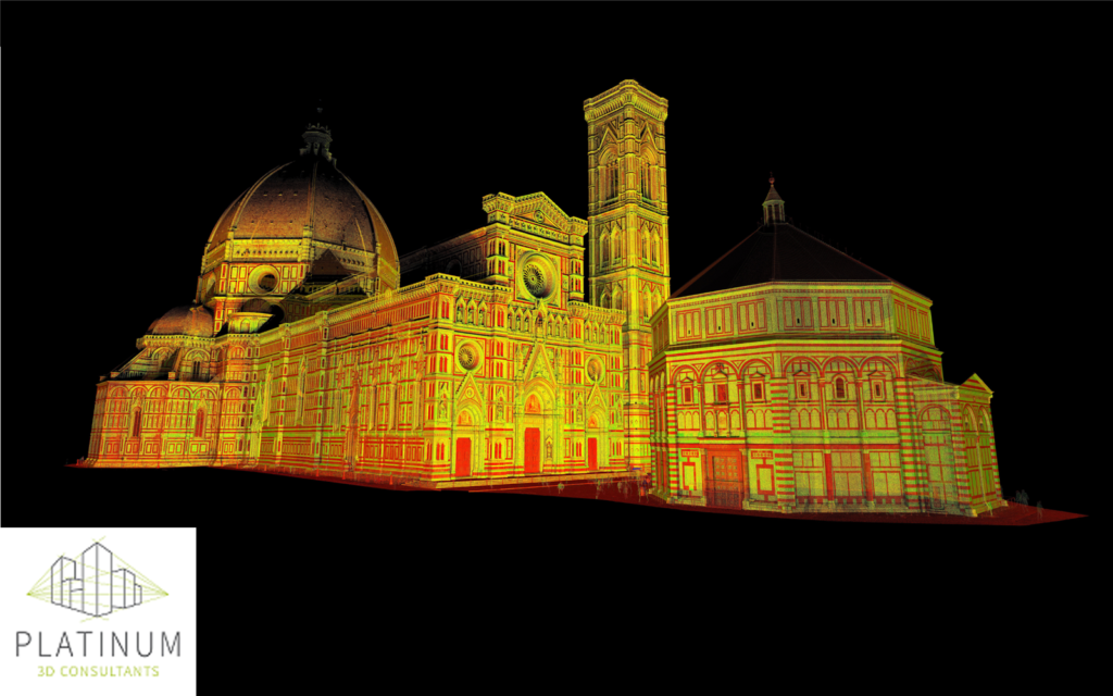
We use laser scanning technology to capture millions of data points, generating a highly accurate point cloud. This data is processed to produce floor plans, elevations, sections, or even full 3D BIM-ready models tailored to your needs.

2. Who Needs a Measured Building Survey?

Measured building surveys are invaluable for a wide range of professionals and projects, including:

  • Architects: To design renovations or extensions with confidence.
  • Engineers: For structural assessments or retrofitting existing buildings.
  • Facility Managers: To streamline maintenance and space utilisation.
  • Property Developers: To ensure accurate area referencing and compliance.
  • Heritage Preservationists: To document and restore historic buildings.

3. What Technology Is Used for a Measured Building Survey?

The cornerstone of modern measured building surveys is laser scanning technology. Using LiDAR (Light Detection and Ranging), laser scanners emit beams of light to capture precise measurements of surfaces, creating a 3D digital representation of the building.

Why Laser Scanning?

  • Accuracy: Achieving millimetre precision.
  • Efficiency: Captures large volumes of data quickly.
  • Non-Invasive: Ideal for fragile or hard-to-reach structures.

At Platinum 3D Consultants, we combine laser scanning with Scan to BIM technology, enabling us to convert point cloud data into BIM-ready Revit models for seamless integration into design workflows.

4. What Are the Deliverables of a Measured Building Survey?

The outputs of a measured survey vary depending on the client’s requirements and project scope. Common deliverables include:

  • 2D Floor Plans: Accurate layouts showing room dimensions, wall placements, and access points.
  • Elevations and Sections: Visual representations of a building’s façade or internal structure.
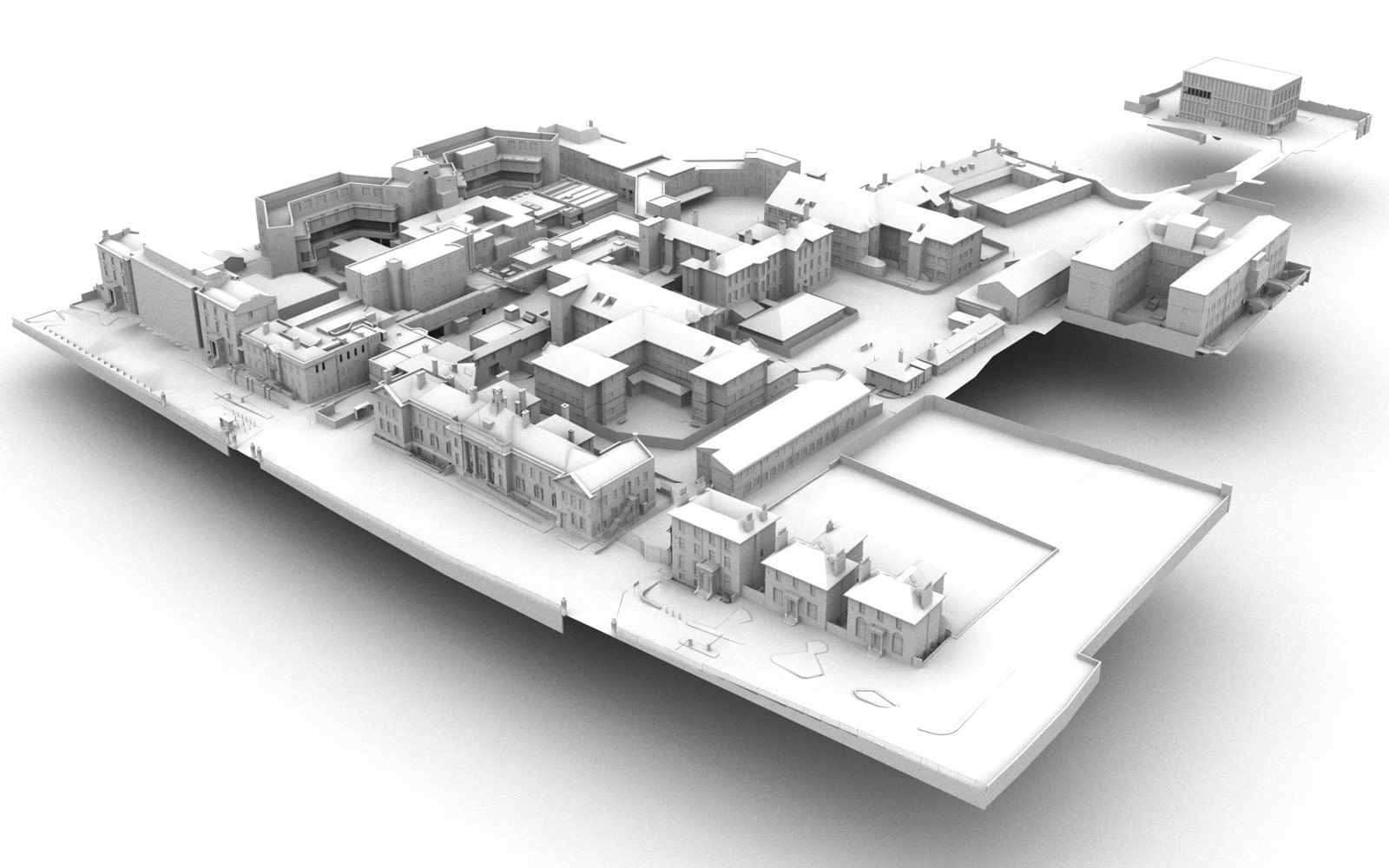
  • 3D Models: BIM-ready models created in software like Revit, which include detailed information for collaborative project planning.
  • Area Referencing: Calculations adhering to RICS or IPMS standards for commercial property transactions.

5. How Accurate Are Measured Building Surveys?

Modern surveys using laser scanning achieve unparalleled accuracy, typically within ±2–6 millimetres. This level of detail ensures that:

  • Designs align seamlessly with the as-built environment.
  • Errors and miscalculations are minimised during construction or renovation.
  • Collaboration between project teams is based on reliable data.
measured building surveying

Platinum 3D’s Commitment:

We deliver surveys with precision and reliability, customised to meet the specific needs of each project, whether it’s a simple floor plan or a complex LOD3 BIM model.

6. How Long Does a Measured Building Survey Take?

The time required depends on factors such as:

  • The size and complexity of the building.
  • The level of detail requested (e.g., basic floor plans vs. intricate BIM models).
  • Site accessibility and conditions.

For instance, a straightforward scan of a small commercial space may take just a few hours on-site, while a detailed survey of a large historic estate could span several days.

At Platinum 3D Consultants, we prioritise efficiency without compromising accuracy, delivering results in a timeline that aligns with your project schedule.

7. Why Choose a Measured Building Survey Over Traditional Methods?

Traditional surveying methods, while effective for basic needs, cannot match the speed, accuracy, or detail provided by modern measured surveys. Benefits of laser scanning include:

  • Comprehensive Data Capture: No risk of missing critical details.
  • Digital Integration: Seamless compatibility with modern design software like Revit.
  • Fewer Re-Visits: All data is captured in one session, reducing disruption.

8. What Are the Benefits of Measured Building Surveys?

Measured surveys bring a wealth of advantages:

  1. Accurate Planning: Ensures designs are based on precise data.
  2. Cost Savings: Reduces errors, rework, and material waste.
  3. Time Efficiency: Speeds up project timelines with reliable data from the outset.
  4. Collaborative Workflows: Provides a shared source of truth for all stakeholders.
  5. Future-Proofing: Supports ongoing maintenance and facility management with digital twins.

9. How Does Platinum 3D Consultants Add Value to Measured Building Surveys?

At Platinum 3D Consultants, we offer a full suite of services to ensure your project is a success:

  • Laser Scanning: High-accuracy data capture for buildings of any size or complexity.
  • Scan to BIM: Creation of BIM-ready Revit models tailored to your needs.
  • Measured Surveys: Deliverables including 2D plans, 3D models, and area referencing.
  • Geo-Referencing: Ensuring spatial accuracy for large or multi-building sites.

Our commitment to innovation, precision, and client satisfaction makes us a trusted partner for projects across sectors, from commercial developments to heritage preservation.

10. How Can I Commission a Measured Building Survey?

Commissioning a survey with Platinum 3D Consultants is straightforward:

  1. Initial Consultation: We’ll discuss your project goals, requirements, and timeline.
  2. Site Survey: Our team will visit the site to perform a laser scan.
  3. Data Processing: We’ll process the data into the agreed deliverables.
  4. Delivery: Receive your floor plans, 3D models, or BIM files in a format ready for use.

Contact us today to get started!

Talk To Platinum 3D Consultants

Whether you’re planning a renovation, managing a facility, or designing a new development, a Measured Building Survey provides the accurate data you need to succeed. With the latest technology and decades of expertise, Platinum 3D Consultants delivers reliable, customised solutions tailored to your project’s needs.

Ready to commission a survey? Get in touch with our expert team today to learn how we can support your project with precision and professionalism. Let’s build smarter, together.

Your Questions Answered: FAQs About Building Measurement and 3D Modelling Services

3D digital models from laser scanning

As building measurement and 3D modelling become essential tools in architecture, construction, and facilities management, more clients are curious about how these services work, what they entail, and why they’re invaluable for projects of all types. At Platinum 3D Consultants, we’re dedicated to delivering highly accurate, data-rich models and measured building surveys that provide clients with a solid foundation for their projects.

In this FAQ, we address some of the most common questions we receive about building measurement, 3D modelling, and the services we offer, including laser scanning, Scan to BIM, and measured building surveys.

1. What Is Building Measurement, and Why Is It Important?

Building measurement is the process of capturing accurate dimensions and structural details of a building, including all critical elements like walls, floors, structural beams, and other architectural features. This is essential for many projects, from renovations to facility management, where precise measurements ensure that designs and installations fit seamlessly within the existing space.

At Platinum 3D Consultants, we offer measured building surveys to provide clients with floor plans, elevations, sections, and area referencing, all of which comply with RICS and IPMS standards. Accurate building measurement helps reduce risks, improve project timelines, and prevent costly mistakes.

2. How Does Laser Scanning Work?

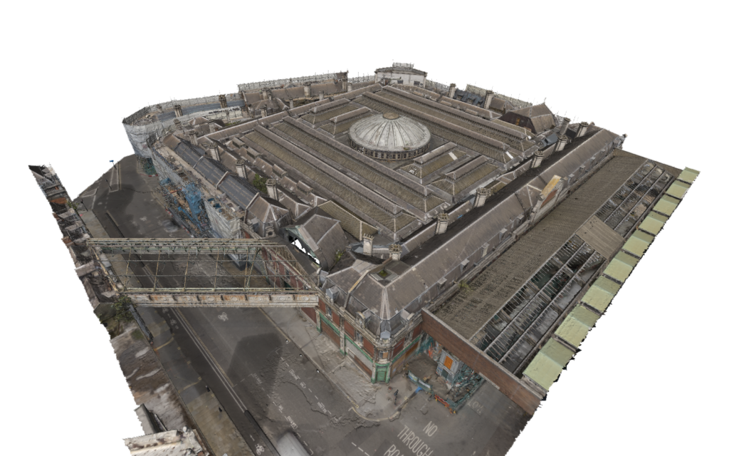
Laser scanning, also known as LiDAR (Light Detection and Ranging), is a surveying method that uses laser beams to capture millions of data points of a building’s surfaces in seconds. This creates a highly detailed point cloud—a 3D dataset representing the building’s exact dimensions and features.

Our laser scanners collect up to a million data points per second, allowing us to capture a detailed snapshot of any building, including complex or intricate structures. This data is then processed to create highly accurate digital models. Laser scanning is non-intrusive, which means it can be used in spaces with limited access or in operational buildings without disrupting daily activities.

scan to BIM

3. What is a Measured Building Survey?

A measured building survey provides essential details of a building’s layout, dimensions, and spatial relationships, creating a clear and comprehensive record of the building’s structure. This type of survey includes floor plans, elevations, sections, and area referencing, ensuring that all necessary information is available for design, planning, and facility management.

Measured building surveys are an important service we provide at Platinum 3D Consultants, as they form the foundation for many of our clients’ projects. By capturing every detail of a building, we ensure that all stakeholders have the accurate information they need for design, renovation, or restoration work.

4. What is Scan to BIM?

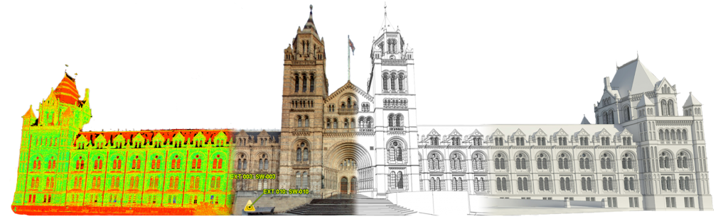
Scan to BIM is the process of using laser-scanned point cloud data to create a BIM-ready model in software such as Revit. This model represents the building’s existing conditions in 3D, providing all structural, architectural, and mechanical information necessary for a wide range of applications.

Our team at Platinum 3D Consultants specialises in Scan to BIM, turning precise survey data into geometrically accurate Revit models. These models allow project teams to collaborate effectively, perform clash detection, and manage every aspect of the building from a single, accurate source.

5. Why Should I Use BIM-Ready Revit Models?

BIM-ready Revit models are extremely valuable because they provide a complete, up-to-date digital representation of a building’s structure, layout, and systems. These models contain rich data about materials, dimensions, and structural elements, all of which are accessible to architects, engineers, and contractors working on the project.

For clients at Platinum 3D Consultants, these models serve as the foundation for collaboration, coordination, and decision-making. BIM-ready Revit models ensure that everyone on the project works from the same, precise data, helping to prevent costly errors and miscommunication.

6. How Accurate is Laser Scanning?

Laser scanning is known for its exceptional accuracy, capturing data points with millimetre precision. This is especially advantageous when dealing with complex or irregular spaces, where traditional measuring methods might fall short. The resulting point cloud data ensures that every detail, from small architectural features to large structural components, is captured with precision.

At Platinum 3D Consultants, we use the latest laser scanning technology to provide our clients with the highest possible accuracy. This precision translates into reliable models and surveys that clients can depend on at every stage of their project.

laser scanning 3D building models

7. Can Laser Scanning Be Used for Older or Historic Buildings?

Absolutely. Laser scanning is particularly beneficial for historic or listed buildings due to its non-intrusive nature and its ability to capture intricate details. Older buildings often have unique architectural features, complex layouts, and materials that require careful documentation. Laser scanning allows us to survey these structures without disturbing their fabric or altering any historic elements.

Our team has extensive experience working on heritage sites, using laser scanning to create detailed digital models that can support restoration efforts, structural analysis, and long-term preservation.

8. What Are the Benefits of Using Geo-Referencing in a Building Model?

Geo-referencing assigns real-world coordinates to a digital model, aligning it within a common coordinate system. This is especially useful for large projects or buildings with multiple sections, as it ensures that each part of the model is positioned correctly within the wider environment.

At Platinum 3D Consultants, we use geo-referencing to make sure that all our models align seamlessly. This means that different teams can work on the same building or even neighbouring structures while maintaining spatial accuracy and consistency across the project.

9. How Long Does It Take to Complete a Survey and Model?

The duration of a project depends on several factors, including the size and complexity of the building and the level of detail required. Laser scanning itself can often be completed in a matter of hours for smaller buildings or within days for larger or complex sites. However, post-processing, such as cleaning up point cloud data and creating a Revit model, can take additional time.

Our team at Platinum 3D Consultants works closely with each client to provide realistic timelines and ensure we deliver accurate models that meet the project’s needs without unnecessary delays.

10. How Can I Use a 3D Model for Future Facility Management?

3D models created through laser scanning and BIM can be invaluable for facility management. By providing a detailed and accurate digital twin of the building, these models allow facility managers to plan maintenance, track assets, and organise space usage more effectively.

For example, a facility manager can use the BIM model to locate utilities, identify the position of structural elements, or manage room occupancy without needing repeated on-site visits. This level of digital access saves time, enhances accuracy, and supports informed decision-making over the building’s lifecycle.

11. How Can Platinum 3D Consultants Help with My Project?

At Platinum 3D Consultants, we provide a full suite of building measurement and 3D modelling services to suit any project, from large commercial renovations to small bespoke restorations. Our services include:

  • Laser Scanning: We capture precise data of the building environment using the latest laser scanning technology.
  • Measured Building Surveys: Detailed surveys that provide clients with essential documentation for floor plans, elevations, and sections.
  • Scan to BIM: Converting point cloud data into BIM-ready Revit models for design, analysis, and collaboration.
  • Geo-Referencing: Ensuring models are correctly aligned within a coordinate system for spatial accuracy.

Our team brings years of experience and a commitment to excellence, helping clients achieve accurate, reliable, and detailed models that serve as a foundation for successful projects. Whether you’re planning a new build, renovation, or facility management, we have the tools and expertise to support your goals.

Talk To Platinum 3D Consultants

Understanding the ins and outs of building measurement and 3D modelling can be a challenge, but it’s also crucial for making informed decisions in any construction, renovation, or maintenance project. We hope this FAQ has clarified some of the key aspects of our services and how they can benefit your project.

If you have more questions or are ready to get started on your next project, reach out to Platinum 3D Consultants. Our team is here to provide the expertise and technology needed to make your vision a reality, from precise measurements to comprehensive digital models.

How The Power of Laser Scanning Is Revolutionising 3D Building Modelling for the Modern Era

laser scanning stadium architectural drawings

In the rapidly evolving world of architecture, construction, and heritage conservation, the demand for precise, detailed, and efficient 3D modelling of buildings has never been higher. Laser scanning technology has emerged as a groundbreaking solution, transforming how professionals capture and visualise existing building structures. Platinum 3D Consultants, with over two decades of expertise, leverage cutting-edge laser scanning technology to create highly accurate Revit models, setting new standards in the industry. But just how does laser scanning work, and why is it so effective? Let’s explore the process, the benefits it brings, and who stands to gain the most from these advanced 3D models.

How Laser Scanning Works: Speed and Precision

Laser scanning, also known as LiDAR (Light Detection and Ranging), is a technique that uses laser beams to capture the exact shape of objects, buildings, and landscapes. By emitting laser pulses and measuring the time it takes for them to bounce back, these scanners can generate up to 1 million data points per second. This process results in a dense ‘point cloud,’ which is a highly detailed, three-dimensional representation of the scanned environment.

At Platinum 3D Consultants, our state-of-the-art 3D scanners can swiftly and accurately map the existing context or environment, capturing every detail with precision. This rapid data collection minimises time on site and reduces the need for multiple visits, making it a highly cost-effective solution. Once the point cloud data is collected, our in-house experts manipulate and enhance it to produce precise 3D models or 2D drawings. This data can also be utilised for clash detection, comparing the as-built object with the virtual model to identify discrepancies and track construction progress.

laser scanning for 3D models of buildings

Why Laser Scanning is So Effective for 3D Modelling

  1. Accuracy and Detail: Laser scanning provides a level of accuracy and detail that is unmatched by traditional measurement methods. The ability to capture millions of data points means that every aspect of the building’s structure is recorded, from large structural elements to minute details. This results in geometrically accurate 3D models of buildings that are essential for precise planning and decision-making.
  2. Efficiency and Speed: Traditional surveying methods can be time-consuming and labour-intensive, often requiring multiple site visits. In contrast, laser scanning significantly reduces time spent on-site, capturing data swiftly and thoroughly. This efficiency not only speeds up the modelling process but also lowers costs, making high-quality 3D models more accessible.
  3. Versatility: Laser scanning is suitable for a wide range of applications, from mapping complex building interiors to capturing expansive landscapes. This versatility allows it to be used in various industries, including architecture, construction, engineering, and heritage conservation.
  4. Enhanced Safety: The ability to scan buildings and structures remotely reduces the need for physical access, especially in hazardous or hard-to-reach areas. This enhances safety for surveyors and minimises the risk of accidents on-site.
3D building modelling laser scanning

The Many Benefits of 3D Laser Scanning Models

The use of 3D laser scanning models brings a multitude of benefits, providing value to a diverse range of stakeholders:

  • Architects and Designers: Accurate 3D models allow architects and designers to visualise and plan projects with greater precision. The detailed point cloud data supports the creation of accurate Revit models, ensuring that designs are based on the exact dimensions and features of the existing structure. This accuracy is crucial for designing modifications or extensions that integrate seamlessly with the current building.
  • Construction Professionals: For builders and contractors, 3D models provide a clear and detailed representation of the project, reducing the likelihood of errors and rework. The ability to conduct clash detection ensures that potential issues are identified early, avoiding costly delays during construction.
  • Facility Managers: Managing and maintaining buildings becomes more efficient with access to precise 3D models. Facility managers can use these models for space planning, asset management, and maintenance scheduling, ensuring that building operations run smoothly and efficiently.
  • Heritage Conservationists: Preserving historic buildings requires detailed documentation of existing conditions. Laser scanning provides an invaluable tool for conservationists, capturing every detail of heritage sites without causing damage. The resulting 3D models serve as digital archives, aiding in the restoration and preservation of cultural landmarks.

The Future of Building Modelling

As technology continues to advance, the role of laser scanning in building modelling is set to expand even further. At Platinum 3D Consultants, we remain at the forefront of this evolution, continually investing in the latest laser scanning technology and software. Our commitment to excellence ensures that our clients receive the most accurate, efficient, and reliable 3D models available.

Laser scanning has revolutionised the way we capture and model the built environment. Its accuracy, efficiency, and versatility make it an indispensable tool for architects, builders, facility managers, and conservationists alike. By embracing this technology, we can build a future where design and construction are more precise, efficient, and sustainable than ever before. 

Contact Platinum 3D Consultants

Ready to experience the precision and efficiency of laser scanning for your next project? Contact Platinum 3D Consultants today to discuss how our expert team can help you create geometrically accurate 3D models and Revit models of your existing buildings. Whether you’re an architect, builder, facility manager, or conservationist, we have the solutions to meet your needs. Get in touch now to discover the benefits of advanced laser scanning technology.