
Complex sites, e.g., mixed‑use buildings, multi‑building estates, constrained urban plots, or heritage properties, bring many hidden challenges. For developers, uncertainty is one of the biggest risks: unknown site conditions, hidden building fabric changes, legal compliance, unexpected costs. Measured building surveys using laser scanning, BIM‑ready Revit models, geo‑referenced point clouds and Matterport virtual tours are tools that can significantly reduce that risk. At Platinum 3D Consultants we help developers gain clarity from day one, enabling smarter decisions, better bids, more accurate cost projections, and smoother planning and delivery.
Why Complex Sites Pose Unique Risks
When a site involves multiple buildings, heritage elements, tight access, or urban constraints, there are many unknowns. Existing drawings may be inaccurate or missing; previous defects or undocumented modifications can be lurking inside walls or ceilings; site constraints (e.g. neighbours, rights of way, party walls, access for plant) may not appear in conventional plans. Environmental risks, structural issues, or services running through difficult‑to‑access places often become expensive surprises. Developers working on urban regeneration, shopping centre redevelopments, or campuses know these issues all too well. A single unforeseen issue can lead to delays, budget overspend, legal challenge or failing to obtain planning or building control approvals in time.
Measured Surveys Give Clarity Before You Buy or Commit
Measured building surveys provide reliable, objective data straight away: a survey of the as‑built condition (using high‑resolution laser scanning) builds a dense point cloud that captures every surface, element, and dimension with millimetre precision. At Platinum 3D we combine that with geo‑referencing, so the scan data is anchored in real‑world coordinates. That means your surveys align with site boundaries, topographical constraints, and neighbouring buildings—important when you’re estimating for demolition, extension, or heritage conservation.
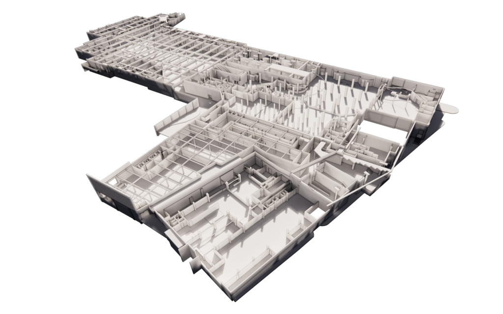
Take the case of the Broadwalk Shopping Centre in Bristol. Platinum 3D surveyed the whole shopping centre, snooker hall, bingo hall, basements and car park. That delivered 2D plans and enabled the developer to understand exactly what needed demolition and what could be retained. Because it was all laser scanned, the client later asked for a 3D model of the basement and loading bay (areas to be retained) without needing another site visit. That saved time and money, and removed risk of misinterpretation. (platinum-3d.com)
BIM‑Ready Models & LOD Levels for Risk Mitigation
Point clouds (the raw data) are hugely useful, but developers benefit even more when that data is turned into BIM‑ready Revit models at sufficient Level of Detail—LOD2, LOD3. Such models include architecture, structure, and often key MEP services. With them you can run clash detection, visualise how new additions or removals will intersect with existing fabric, schedule works with confidence, and predict costs of services relocations or replacements.
For example, in heritage estate upgrades, LOD3 models show you the size and shape of historic windows, the thickness of walls, or the location of original materials—helping satisfy planning constraints and conservation bodies. Such models also feed into long‑term FM (Facilities Management) planning so once built, the site can be maintained, upgraded or adapted with less disruption and fewer unknowns.
Matterport Virtual Tours: Visual Context & Stakeholder Communication
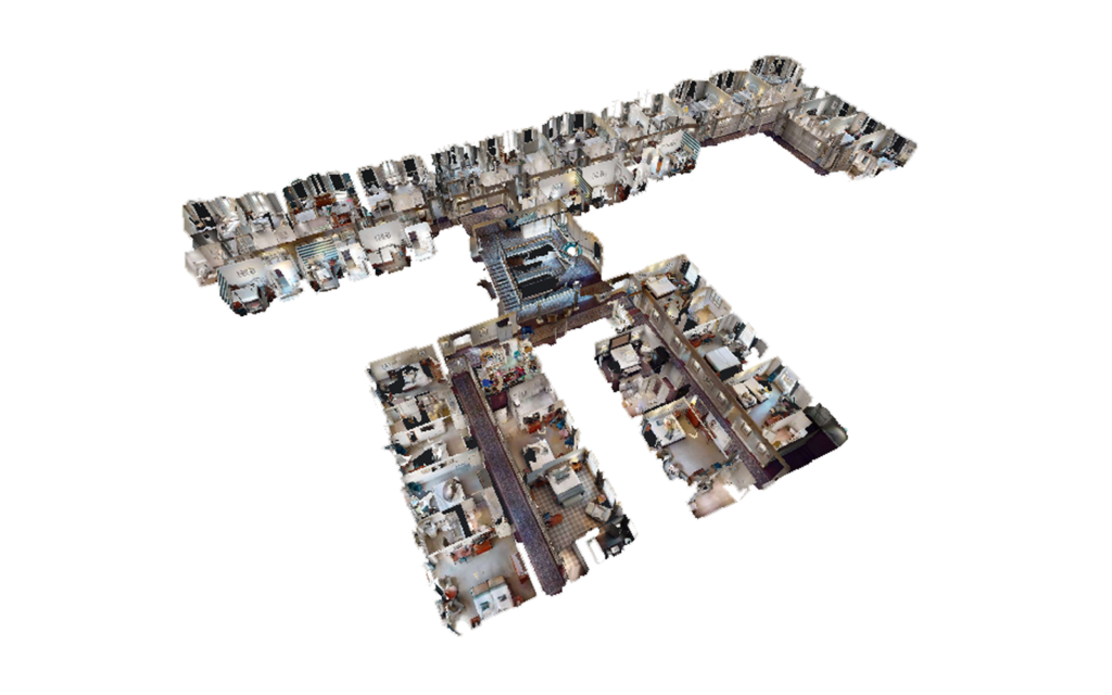
While technical teams can use BIM models and point clouds, many stakeholders (clients, planners, local councils, community, marketing teams) benefit from visual tools. Matterport virtual tours deliver immersive, photo‑real walkthroughs of existing buildings. They allow viewers to see actual site conditions: layout, lighting, condition of finishes, or even damage. Tours may be tagged with areas needing attention: for example, water damage, corrosion, or planned structural changes.
Developers can use these tours in presentations, planning submissions, or tender packages. For constrained urban sites or heritage buildings where access or visibility is limited, a Matterport tour gives a safe, convenient way for decision‑makers to familiarise themselves with site challenges without being onsite constantly.
Geo‑Referenced Point Clouds: Context, Compliance & Costing
One of the most powerful benefits is geo‑referencing. If your point cloud is aligned with real world coordinates, you can overlay surveys with maps, site boundaries, topography, rights of way and even local authority GIS data. That helps with accurate legal boundary definitions, rights of light analysis, party wall issues, and planning setbacks. It also helps when calculating volumes of demolition or cut/fill in redevelopments, or when assessing site constraints such as utilities or underground services.
Real Estate Redevelopment & Heritage Acquisition Use Cases
Developers acquiring heritage estates, shopping centres, or campuses are among those who most benefit. For example, when redeveloping a mixed‑use site, understanding exactly which parts of buildings are structurally sound, which facades are listed, or which services are non‑compliant—all before acquisition—lets you set realistic costs and timelines. Redevelopment of campuses (e.g. for student accommodation or mixed use), or urban infill projects similarly benefit from reliable data in a congested site where neighbour interfaces, elevation changes, façade sightlines and constraints will affect design.
How Platinum 3D Supports Developers to De‑Risk from Day One
Our approach at Platinum 3D Consultants is tailored to developer needs:
• We begin with a detailed briefing to understand site history, constraints, intended redevelopment scope and stakeholder group.
• We deploy laser scanning to generate accurate point clouds, capture all relevant geometry and service runs, even where access is limited.
• We combine with geo‑referencing so the survey relates to external topography, legal boundaries and digital maps.
• Our in‑house Revit team produces BIM‑ready models at LOD2 or LOD3 depending on project scale, integrating structure, envelope, and services where needed.
• We provide virtual tours via Matterport or similar platforms for visual clarity for non‑technical stakeholders.
• All deliverables are shared in formats compatible with planning, design, FM and costing teams.
The Outcomes: Reduced Risk, Better Decisions, Tighter Budgets
By using measured surveys early, developers can reduce risk of unexpected costs, make informed bids, deliver better planning application submissions, lower chances of planning or regulatory rejection, and reduce overspend from rework. Early detection of clash conflicts, heritage constraints, structural non‑compliance or hidden elements means fewer surprises mid‑build. Confidence in condition, site boundaries, legal constraints and services improves pricing models and financing arrangements.
Talk To Us
In redevelopment or acquisition of complex sites, the difference between success and delay, or between profit and loss, often rests on what you do before you commit to a plan. Measured building surveys using laser scanning, geo‑referenced point clouds, LOD3 BIM models, and visual tools like Matterport tours equip developers to de‑risk early, bid more accurately, plan more confidently, and ultimately deliver more predictably. If you’re a developer facing a mixed‑use, constrained or heritage‑affected site, then bring in Platinum 3D Consultants early.
Let’s talk about how our surveying, modelling and tour tools can help you reduce risk and increase value from Day One.